- NEXT 12 HOURS: Tornado Watch until 8 p.m. Friday evening
- THIS WEEKEND: Much colder, breezy Saturday
- NEXT WEEK: A lot of sunshine, warming up
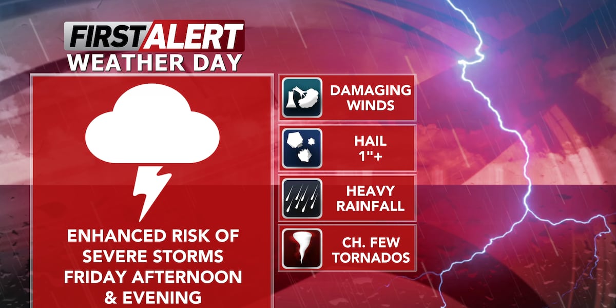
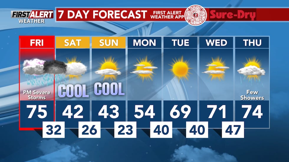
WAUSAU, Wis. (WSAW) – Friday will be the third and final round of severe weather of the week across north central Wisconsin. In the wake of these storms, chillier conditions on tap for the weekend. Temps look to rebound some in the new week.
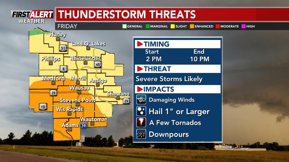
High temperatures will top out in the low to mid-70s for most of the area (upper-70s are possible in communities further south). We will hit these highs before thunderstorms arrive. Friday remains a First Alert Weather Day due to the likelihood for severe weather Friday afternoon and evening. All threats are possible with these storms, including hail, strong wind gusts, and a few tornados. A severe thunderstorm watch is active until 5 PM this evening, but we will likely be upgraded to a tornado watch during the early afternoon.
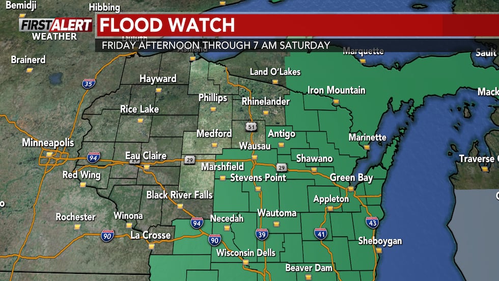
Several counties have also been placed under a Flood Watch due to ongoing flooding along rivers along with the potential for heavy rain from the thunderstorms. Some of us could, once again, pick up 1-2+” of rain by the time storms are done very late Friday.
Be sure to have two ways to stay weather aware on Friday. The First Alert Weather App is your best resource, along with NOAA Weather Radio, and keeping it tuned to Newschannel 7 as conditions warrant on Friday for impacts from severe storms.

A cold front will sweep through north central Wisconsin after storms are out of the area, and we will cool off significantly into Saturday morning. Gusty winds can be expected throughout Friday leading up to storms (wind gusts as high as 25-35 MPH).
What’s coming up
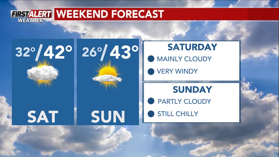
This weekend will be MUCH colder than the last several days. Temperatures drop close to freezing by Saturday morning. A light wintry mix to snow cannot be ruled out in some communities, but accumulations are not expected due to the ground being warmed up from the warmer temperatures over the last several days. Highs on Saturday top out in the upper-30s and low-40s with mainly cloudy skies. Any precipitation behind the cold front should be mostly wrapped up by midday. Outside of thunderstorm wind gusts, Saturday has a good chance to feature our strongest wind gusts over the next few days as wind gusts could reach 35-40 MPH.
Sunday will feature “calmer” winds, but will still be somewhat breezy with wind gusts as high as around 20-25 MPH. Skies are trending partly cloudy with highs in the low to mid-40s once again.
Looking ahead
Heading into next week, warmer weather returns. This time, we’re looking at a MUCH quieter week (especially in terms of severe weather). Skies are trending mainly sunny for the majority of next week as highs are back in the upper-60s and low-70s by Tuesday next week. Outside of the storms today and maybe a little mixed precipitation on Saturday, precipitation is unlikely from Sunday onwards through most of next week. This means that rivers south of Highway 29 will mainly crest over the next few days before river levels drop overall heading into next week as we enter a dry period.

Here’s a look at your First Alert Weather Forecast for central Wisconsin over the next 12 hours. Don’t forget to check back for the latest forecast.
Click here to download the WSAW News app or our WSAW First Alert weather app. Submit Weather photos here!
Copyright 2026 WSAW. All rights reserved.