GOOD MORNING. TIME NOW IS 516. AND WE’RE TAKING A LOOK AT ORIOLE PARK. WE ARE GOING TO SEE MANY FANS FLOODING INTO CAMDEN YARDS FOR THIS EVENING AS WE HAVE. THE O’S ARE BACK AT HOME STARTING A NEW SERIES AGAINST THE RED SOX. BUT LET ME TELL YOU, WE’RE ALSO GOING TO BRING IN SOME UNSETTLED WEATHER TOWARDS THIS EVENING AND INTO THE WEEKEND, SO YOU REALLY WANT TO GET A CLOSE. KEEP A CLOSE EYE ON THE FORECAST OVER THE NEXT FEW DAYS. WE’RE ACTUALLY STARTING OFF VERY DRY. SO LET’S ENJOY THAT WHILE IT LASTS. DRY AND MILD. 59 AT BWI MARSHALL 61 DOWNTOWN. WE’RE LOOKING AT 53 IN BEL AIR, 59 IN WESTMINSTER. AGAIN, IT IS PRETTY DRY. WE SAW THAT THERE ON THAT LIVE SHOT OF CAMDEN YARDS, WHERE WE’RE NOT SEEING ANY WET WEATHER FALLING FROM THE SKY, BUT ALSO INTO THE BEGINNING. HALF OF THE AFTERNOON WE’RE DRY. TEMPERATURES ARE GOING TO BE MILD. ONCE AGAIN, WE’RE LOOKING AT 77 FOR THE AFTERNOON, HIGH IN BALTIMORE, 80 IN WESTMINSTER, 81 IN FREDERICK. BUT BY THE TIME WE MAKE OUR WAY PAST THAT NOON HOUR, THAT’S WHEN OUR CHANCES FOR RAIN WILL BEGIN TO INCREASE. IT WILL BE VERY ISOLATED IN NATURE AND BECAUSE OF THAT, DON’T REALLY WANT TO CANCEL YOUR PLANS TO HEAD TO THE GAME. CANCEL YOUR PLANS TO GO ANYWHERE. JUST HAVE A PLAN IN PLACE JUST IN CASE YOU GET CAUGHT IN SOME OF THOSE SHOWERS AND THUNDERSTORMS. HERE’S A LOOK AT YOUR FIRST FORECAST. FIRST PITCH AGAINST THE RED SOX TONIGHT WILL BE AT 705. 70 DEGREES IS GOING TO BE THE TEMPERATURE AT FIRST PITCH. AND LOOKING AT PARTLY CLOUDY SKIES. BUT AGAIN, THERE WILL BE A CHANCE OF SHOWERS AND THUNDERSTORMS. SO DEPENDING ON WHERE THEY SET UP, COULD SET UP RIGHT OVER CAMDEN YARDS. SO AGAIN, HAVE A PLAN IN PLACE. NOW LOOKING INTO OUR SERIES AHEAD, ISOLATED SHOWERS AND THUNDERSTORMS TODAY. CHILLY AND RAINY TOMORROW. THAT’S WHERE WE CAN EXPECT SOME MORE WIDESPREAD RAINFALL TO BE IN THE REGION. FIRST PITCH ON SATURDAY WILL BE AT 405 AND THEN 135. FIRST PITCH ON SUNDAY WITH ANOTHER CHANCE OF ISOLATED SHOWERS. HERE’S A LOOK AT THIS EVENING. YOU SEE THE SHOWERS BEGINNING TO BUBBLE UP AND IN. AND AT THAT 3:00 HOUR. ANOTHER CHANCE OF RAIN AND WE COULD SEE A FEW CHANCES IN THE MORNING HOURS FOR SATURDAY. AND THEN HERE’S A LOOK AT THE AFTERNOON WHERE WE HAVE THAT COLD FRONT REALLY KICKING OFF SOME SHOWERS INTO THE AFTERNOON AND EVENING ON SATURDAY. SUNDAY WE’LL HAVE THE RAIN EARLY ON, BUT THEN CLOUDY SKIES WILL STICK AROUND THROUGHOUT THE DAY. SURE YOU HAVE THE RAIN GEAR CLOSE BY. LOOK AT THE TEMPERATURES TO YOU. WANT TO HAVE A JACKET WITH YOU
The warmer trend will continue into Friday across the Baltimore area before a cooler rain develops for the weekend.Storms possible Friday Clouds increased across the Baltimore region Friday afternoon, ushering in thunderstorms. Scattered storms are possible throughout the evening, including during the Orioles game.It’ll still be warm, though, with temperatures in the 70s. Cooler and rainy weekendYou may want to find some indoor activities this weekend, with the cooler temperatures and rain. Showers are possible anytime on Saturday, but they will increase by Saturday afternoon and evening. Highs will be in the low 60s.The rain will taper off on Sunday morning, but the rest of the day will stay cloudy and chilly with highs in the 50s. Throughout the weekend, the wind will be brisk, from the east around 10-15 mph, adding to the chill.Maryland’s 7-Day Weather ForecastThe sunshine will return on Monday, with additional rain showers possible by the middle of next week. || Closings/Delays | Weather Advisories | Radar | Forecast | Email Alerts | Send us your pics ||Download the WBAL-TV app NOW and turn on push alerts to be aware of severe weather warnings, listen to NOAA Weather radio, and watch WBAL-TV 11 when impending severe weather develops.@wbaltv11 | @TTasselWBAL | @AvaWBAL | @TonyPannWBAL | @DalenciaWBAL | @AlenaLeeWX
The warmer trend will continue into Friday across the Baltimore area before a cooler rain develops for the weekend.
Storms possible Friday
Clouds increased across the Baltimore region Friday afternoon, ushering in thunderstorms. Scattered storms are possible throughout the evening, including during the Orioles game.
It’ll still be warm, though, with temperatures in the 70s.

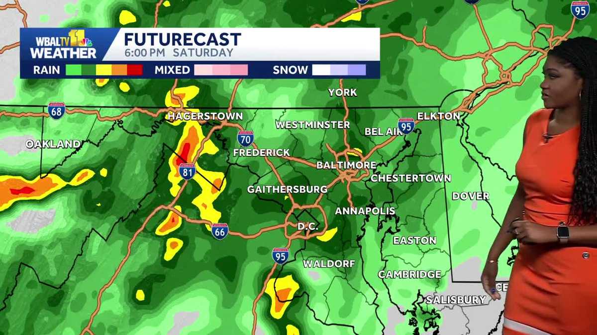
Cooler and rainy weekend
You may want to find some indoor activities this weekend, with the cooler temperatures and rain. Showers are possible anytime on Saturday, but they will increase by Saturday afternoon and evening. Highs will be in the low 60s.
The rain will taper off on Sunday morning, but the rest of the day will stay cloudy and chilly with highs in the 50s. Throughout the weekend, the wind will be brisk, from the east around 10-15 mph, adding to the chill.
Maryland’s 7-Day Weather Forecast
The sunshine will return on Monday, with additional rain showers possible by the middle of next week.

|| Closings/Delays | Weather Advisories | Radar | Forecast | Email Alerts | Send us your pics ||
Download the WBAL-TV app NOW and turn on push alerts to be aware of severe weather warnings, listen to NOAA Weather radio, and watch WBAL-TV 11 when impending severe weather develops.
@wbaltv11 | @TTasselWBAL | @AvaWBAL | @TonyPannWBAL | @DalenciaWBAL | @AlenaLeeWX