Spring is plodding along in the Pacific Northwest and I’d argue it’s been a “nice” spring. By that I mean we’ve had a good mix of warm & cool periods. Just look at April so far…cool and gray days (today), then sunny and warm days (Easter Sunday).
Rain has been close to average for most parts of the region. Slightly below in some spots, slightly above in others

At this point, we’re more than halfway through meteorological spring. I just checked a bunch of long-term climate stations and most areas are seeing a Top 5-15 warmest spring so far. In Portland it’s running 9th warmest (records go back about 85 years). Last year was warmer at this point and so was 2024. Yep, springs have been a bit warmer recently.

Still, the warm weather this past winter brought us a dismal snowpack and now much of that is already gone. Most areas in the northern Oregon Cascades below 4,500′ are already snow-free. At 5,400′ on Mt. Hood, 49″ remains on the ground, but the next week will take quite a toll on that. The black line is this year, red is lowest on record, and green is average for any year

The earliest “snow-free” date at this location was May 24th. We’ll see how much is left this year by that date.
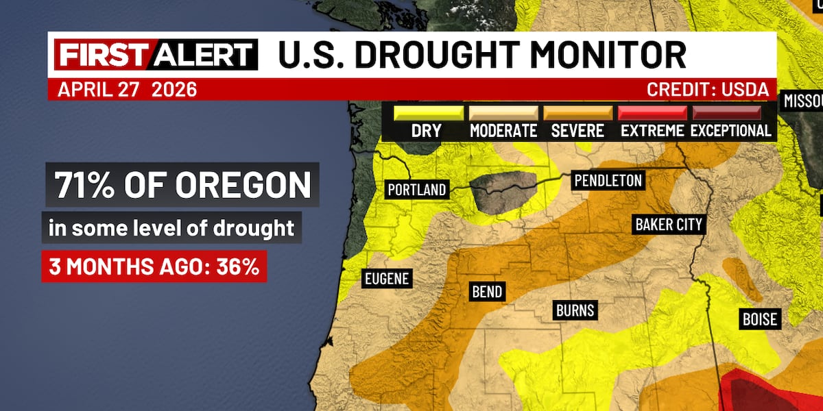
Of course drought conditions have spread across the region as the snowpack disappears.

Almost 3/4 of Oregon is in some form of drought at this point and most likely conditions will go downhill as we head into the dry season
WHAT’S AHEAD?
Warmer and drier than normal is the story for the next 7-10 days as most weather systems either move around the Pacific Northwest or split apart as they approach. The reason is persistent upper-level ridging remaining somewhere near the West Coast. Check out the 500 millibar height anomaly forecast for the next 5 days…the warm colors represent higher than normal heights for this time of year. That’s a pretty strong positive anomaly off the PACNW and BC coastline.

Forecast models are zeroing in on a much warmer atmosphere arriving overhead Saturday and Sunday. Notice excellent agreement on 850mb temps around or a little above +15° C late Saturday and Sunday. In May, that temp along with light easterly wind (also forecast Sunday) means temperatures should soar into the 80s. In fact mid-upper 80s are possible in early May with this pattern. The perfect setup for very warm to almost hot weather shows up in this chart for next Sunday. Easterly flow across the Cascades around 4,000′. Temperatures at that elevation are running 20-25° above normal!

For now we’re forecasting just below 80 on Saturday then well into the 80s Sunday and Monday. Record highs are generally around 90 in early May, so it’s unlikely we break a record.
Now see days 6-11 (the first week of May). Higher heights continue, which tends to give us more sinking and drying of the airmass than we typically see in early May.

Finally, looking way out at Week 2, the Euro AI Forecast System (AIFS) says the relatively warm and dry pattern continues.

There’s sure no sign of a significant cool/wet period. I’m just showing you one ensemble forecast system, but other models are generally similar. Check out the precipitation anomaly for the next 15 days from the GFS…much drier than normal.

SUMMARY
Plan on an early taste of warm summer weather again this coming weekend. But this time instead of high temps AROUND 80, we’ll head INTO the 80s.
Also, by this weekend, your potted plants outside are going to need watering. Don’t forget anything else newly planted in the ground. By next week, assuming no significant rain falls, it’ll be time to start watering plants in the ground. Some springs we can get by without much watering until late May or so, but it appears this year we’ll be starting early.
Copyright 2025 KPTV-KPDX. All rights reserved.