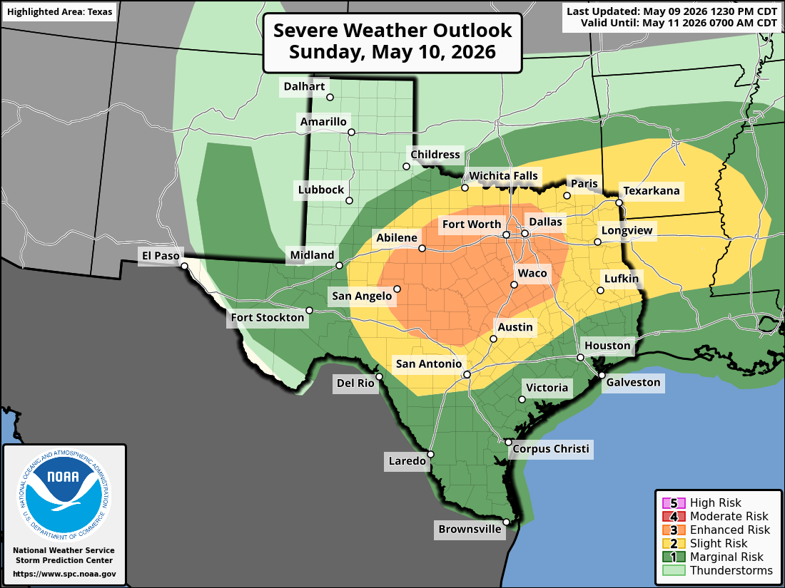
Much of Texas is under a level 2 to 3 risk of severe thunderstorms on Sunday, as a cold front is expected to push through during the evening.
The few cool and cloudy days we’ve recently had in South Texas will be interrupted by more spring-like weather again this weekend. Not only will temperatures rise back into the 80s and low 90s, but we also face a rising threat of scattered but strong thunderstorms, especially by the second half of the day on Sunday.
If you have early Mother’s Day plans, don’t worry, as most of Texas will stay dry through the late afternoon. However, a cold font is expected to quickly move through Texas by Sunday evening, and strong thunderstorms are expected to develop alongside it. Here’s a look at how the next 48 hours will play out.
Article continues below this ad
Saturday’s forecast
A cloudy and muggy morning is anticipated across South and Central Texas on Saturday, as temperatures will sit in the low to mid-70s through 10 a.m. With such high levels of atmospheric moisture in the area, a few isolated showers and storms are possible through the morning. Overall rain chances will be just 20% in San Antonio, though.
Clouds are expected to decrease by the middle of the day, allowing temperatures to steadily rise. San Antonio will likely experience afternoon temps in the upper 80s, but the humidity will cause temperatures to feel like the 90s.
A few thunderstorms might also develop during the afternoon, mainly between 3 p.m. and 7 p.m. Storms will stay isolated, though, keeping rain chances at around 20%. Much of South Texas will stay dry.
Article continues below this ad
Mother’s Day forecast
Before the severe weather threat takes hold, most of Sunday will be dry across Texas. Morning temperatures in San Antonio will be in the 70s, likely rising into the lower to mid-80s by noon. The afternoon is expected to reach the lower 90s, as uncomfortably high humidity levels are also expected to continue.
Storms developing: A cold front is expected to start pushing through North Texas by Sunday afternoon. The front is expected to move south into the Hill Country by 7 p.m., eventually reaching the San Antonio area by around 9-10 p.m.
Article continues below this ad
As the front interacts with the already humid air mass, thunderstorms are likely to form alongside it. These storms could strengthen quickly, producing large hail and damaging wind gusts.

A potential weather radar image for 7 p.m. Sunday shows a line of strong thunderstorms heading toward South and Central Texas along a cold front. San Antonio’s best chance of storms will occur after 8 p.m.
The National Weather Service’s Storm Prediction Center has placed much of Texas under a risk of severe weather. The highest risk is across the middle of the state, including the Dallas-Fort Worth metroplex, Waco, Abilene, and San Angelo. This region is under a level 3 of 5 risk for severe thunderstorms.
Farther south, Austin and San Antonio is under a level 2 risk, as storms may potentially weaken slightly as they move south. Still, several storms in this region may be capable of producing large hail and damaging wind gusts.
Article continues below this ad
San Antonio will have about a 60% to 70% chance of thunderstorms, with the highest chances occurring between 8 p.m. and midnight. Storms may also produce frequent, intense lightning, as well as heavy downpours.
A look at next week
Sunday’s cold front will result in only a small drop in temperatures by early next week. Monday morning temperatures in the upper 60s will rise into the mid-80s by the afternoon. Partly cloudy skies are expected early, turning mostly sunny by the afternoon.
Article continues below this ad
Very similar weather is expected Tuesday, as temperatures once again rise into the mid-80s. A slight warming is coming for the second half of the week, with afternoons in the upper 80s to near 90 degrees from Wednesday through Friday.
Thunderstorm chances will stay very low throughout the week, as high atmospheric pressure is expected to build over the state. The next significant chance of rain won’t arrive until at least May 16-18.