Wednesday’s Orioles game moved up because of weather
The risk for rain and thunder will increase later on Wednesday as a cold front moves through
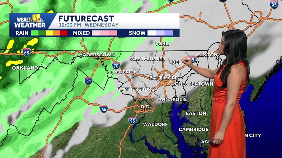
OKAY. WELCOME BACK. IT’S 516 ON A WEDNESDAY MORNING. IMPACT WEATHER DAY. RIGHT NOW IT’S MAINLY DRY AS WE LOOK LIVE FROM PATTERSON PARK. YOU CAN SEE THE CLOUDS THOUGH. THEY’RE GOING TO PRETTY MUCH CONTINUE TO THICKEN THROUGHOUT THE DAY BEFORE OUR NEXT SYSTEM PUSHES THROUGH THIS AFTERNOON INTO THE EVENING. AND IN TERMS OF SEVERE WEATHER, NOT A HUGE OR HIGH THREAT FOR THAT LATER ON TODAY, BUT THE STORM PREDICTION CENTER EXTENDING THE ISOLATED SEVERE WEATHER RISK A LITTLE BIT FARTHER EAST. NOW, HOWEVER, HERE IN THE BALTIMORE AREA, INCLUDING THE COUNTY, LIKELY JUST GOING TO BE DEALING WITH SOME PRIMARILY RAIN, MAYBE EVEN A GUSTY WIND OR TWO, AS YOU SEE ON OUR FUTURECAST MODEL. WE STOP HERE, START HERE AT 6:00, WHERE THE CLOUDS WILL CONTINUE TO INCREASE ACROSS THE AREA, BECOMING MOSTLY CLOUDY ALL THE WAY THROUGH MIDDAY, BUT MAINLY DRY. HOWEVER, AFTER THE LUNCH HOUR I WOULD SAY BETWEEN TWO AND EVEN 6 P.M., SHOWERS WILL BE SCATTERED ACROSS THE AREA, MAYBE A BRIEF THUNDERSTORM, BUT FOR THE MOST PART, ANY STORM THAT FORMS WILL BE OUT IN WESTERN MARYLAND. IT WILL JUST BE PRIMARILY RAIN THAT WE DEAL WITH HERE ACROSS CENTRAL MARYLAND AND THE EASTERN SHORE. ANOTHER ROUND OF RAIN MOVES IN LATE TONIGHT, ESPECIALLY CLOSER TO SUNSET AND BEYOND ALL THE WAY THROUGH MIDNIGHT TONIGHT. EXPECT FOR THAT SECOND ROUND OF SHOWERS AND EVEN SOME THUNDERSTORMS THAT MAY PRODUCE HEAVIER RAIN, A LITTLE BIT OF A GUSTY WIND ALSO, AND SOME FREQUENT LIGHTNING ASSOCIATED WITH ANY GENERAL THUNDERSTORM THAT WE SEE. AGAIN, THE SEVERE THREAT VERY LOW, BUT IT’S OUT THERE IN WESTERN MARYLAND WITH THE PRIMARY THREAT BEING DAMAGING WIND, AS YOU NOTICE HERE, 7:00 TOMORROW MORNING, THERE WILL STILL BE SOME RAIN AROUND OR SO LIGHT SPOTTY SHOWERS CAN’T BE RULED OUT TO WAKE UP TO CLOUDS CLEAR OUT. BUT THEN WE COULD SEE AN ADDITIONAL ROUND OF AN ISOLATED SHOWER OR SPOTTY SHOWERS OUT THERE DURING THE AFTERNOON AND EVENING ON THURSDAY. THEN WE DRY OUT EVERYWHERE AND FRIDAY SHOULD BE DRY AS WELL, BUT OUR WARMING TREND WILL START THEN AND CONTINUE FOR SEVERAL DAYS. WE’LL TALK ABOUT THIS HEAT IN JUST A MOMENT. KIND OF WANT TO BREAK DOWN THE IMPACT WEATHER FOR YOU TODAY. AGAIN, TWO ROUNDS OF RAIN LIKELY FIRST ROUND BETWEEN NOON AND 6 P.M., BUT MORE LIKELY. SO HERE IN THE BALTIMORE AREA BETWEEN 4 AND 6, I WOULD SAY, BUT AT LEAST MOVING INTO PARTS OF THE WESTERN PART OF OUR VIEWING AREA AS EARLY AS LUNCHTIME. BUT THE THREATS WILL BE HEAVY RAIN, LIGHTNING, GUSTY WIND AGAIN, SEVERE THREAT, MARGINAL RISK. RIGHT NOW FOR WESTERN MARYLAND, I THINK THE PRIMARY IMPACTS FOR ANY RAIN THAT WE GET, OBVIOUSLY WET ROADS THAT COULD SLOW DOWN YOUR TRAVEL TIMES. HERE’S A LOOK AT YOUR FORECAST FOR TODAY 73 YOUR HIGH. IT’S ALSO GOING TO BE A BREEZY DAY. SOUTHWEST WINDS IN PLACE 1015MPH. COULD GUST BETWEEN 25 AND 30 AT TIMES. OUTSIDE OF ANY THUNDERSTORMS. OF COURSE, TONIGHT RAIN WILL BE LIKELY AND IT WILL BE ANOTHER COOL ONE. TEMPERATURES DROP INTO THE 50S ALL THE WAY THROUGH DAYBREAK ON THURSDAY. SO HERE’S AN UPDATE TO YOUR ORIOLES FORECAST. AGAIN, JUST A REMINDER, IF YOU DIDN’T KNOW THEY HAVE SHIFTED THE GAME A LITTLE BIT EARLIER TO GET THAT DONE BEFORE THE RAIN ARRIVES. FIRST PITCH NOW 105 I THINK WILL BE IN THE LOW 70S WITH A FEW SPRINKLES POSSIBLE, BUT MAINLY DRY FOR AT LEAST A FEW HOURS UNTIL WE GET INTO NINTH INNING. THAT’S WHERE I THINK WE’LL HAVE THAT CHANCE OF RAIN DEVELOP. ALL RIGHT. SEVEN-DAY FORECAST NEXT 70 RETURNING ON FRIDAY, 80 THIS UPCOMING WEEKEND AND THE POTENTIAL TO REACH NEAR 90 EARLY NEXT WEEK. LOOKS LIKE THIS WARM UP WILL LAST FOR SEVERAL DAYS. SO IF YOU ARE A BIG SUMMER WEATHER FAN, NEXT WEEK IS DEFINITELY FOR YOU. AND ALSO, JUST TO NOTE THOSE SLIM CHANCES OF RA
Wednesday’s Orioles game moved up because of weather
The risk for rain and thunder will increase later on Wednesday as a cold front moves through
Updated: 6:25 AM EDT May 13, 2026
The Baltimore Orioles have moved up Wednesday’s game because of the risk for showers and storms. Temperatures will briefly dip on Thursday before turning summery over the weekend. Impact Weather Wednesday Wednesday will start out pleasant, with some sunshine and temperatures climbing from the 50s into the 70s. The Orioles have moved up their first pitch time on Wednesday to 1:05 p.m., to try to get ahead of the rain and storms that will develop in the afternoon and evening. The odds are in their favor that the game will start dry, but showers are possible as the game goes on. But luckily, with the earlier start time, the risk for lightning should hold off until after the game.There will be a second round of rain in the evening, coming with the cold front. This second round is more likely to be heavier, possibly with gusty winds and lightning, as well. The storms will taper after midnight, followed by cooler winds on Thursday. Maryland’s 7-Day Weather Forecast A few showers could linger on Thursday and it will be much cooler on as well. With a brisk northwest wind, highs on Thursday will only be near 60 degrees.After a cool start to May, it will finally feel more summery over the weekend. On Saturday, highs will climb to the low 80 degrees. Sunday will be even warmer, in the upper 80s. Over the weekend, there may be a few brief showers, but most of it looks dry.Next week will feel even hotter, with highs near 90 degrees with higher humidity. This hotter weather could eventually lead to thunderstorms during the middle of next week.Stay InformedDownload the WBAL-TV 11 News app and turn on push alerts to be aware of changing weather and watch WBAL-TV 11 News for updates.Follow the WBAL-TV 11 Weather Team on X: @wbaltv11 | @TTasselWBAL | @AvaWBAL | @TonyPannWBAL | @DalenciaWBAL | @AlenaLeeWX|| Closings/Delays | Weather Advisories | Radar | Forecast | Email Alerts | Send us your pics ||WBAL-TV 11 Maryland Weather RadarApp users tap here for interactive radar.Share Your PhotosShare your weather photos and videos and we may show them on WBAL-TV 11 News or online!DIRECT UPLOAD: Use this form to upload photos and video.EMAIL: Email your photos and video to news@wbaltv.com.
The Baltimore Orioles have moved up Wednesday’s game because of the risk for showers and storms. Temperatures will briefly dip on Thursday before turning summery over the weekend.
Impact Weather Wednesday
Wednesday will start out pleasant, with some sunshine and temperatures climbing from the 50s into the 70s.

The Orioles have moved up their first pitch time on Wednesday to 1:05 p.m., to try to get ahead of the rain and storms that will develop in the afternoon and evening. The odds are in their favor that the game will start dry, but showers are possible as the game goes on. But luckily, with the earlier start time, the risk for lightning should hold off until after the game.
There will be a second round of rain in the evening, coming with the cold front. This second round is more likely to be heavier, possibly with gusty winds and lightning, as well. The storms will taper after midnight, followed by cooler winds on Thursday.
This content is imported from Twitter.
You may be able to find the same content in another format, or you may be able to find more information, at their web site.
Maryland’s 7-Day Weather Forecast
A few showers could linger on Thursday and it will be much cooler on as well. With a brisk northwest wind, highs on Thursday will only be near 60 degrees.
After a cool start to May, it will finally feel more summery over the weekend. On Saturday, highs will climb to the low 80 degrees. Sunday will be even warmer, in the upper 80s. Over the weekend, there may be a few brief showers, but most of it looks dry.
Next week will feel even hotter, with highs near 90 degrees with higher humidity. This hotter weather could eventually lead to thunderstorms during the middle of next week.

Stay Informed
Download the WBAL-TV 11 News app and turn on push alerts to be aware of changing weather and watch WBAL-TV 11 News for updates.
Follow the WBAL-TV 11 Weather Team on X: @wbaltv11 | @TTasselWBAL | @AvaWBAL | @TonyPannWBAL | @DalenciaWBAL | @AlenaLeeWX
|| Closings/Delays | Weather Advisories | Radar | Forecast | Email Alerts | Send us your pics ||
WBAL-TV 11 Maryland Weather Radar
App users tap here for interactive radar.

Share Your Photos
Share your weather photos and videos and we may show them on WBAL-TV 11 News or online!