A flood watch is in effect for several northern Missouri counties after heavy rainfall Saturday night. More rain is possible Sunday. Anyone driving overnight or early in the morning should use caution. Do not drive into floodwaters. A severe thunderstorm watch is in effect until 6 a.m. Sunday for the following counties in Missouri: Andrew, Atchison, Buchanan, Caldwell, Clinton, Daviess, DeKalb, Gentry, Grundy, Harrison, Holt, Linn, Livingston, Mercer, Nodaway, Putnam, Sullivan and Worth. This watch also includes Atchison and Doniphan counties in Kansas. Kansas City region weather updates: 12:15 p.m. – A severe thunderstorm warning is in effect until 1 a.m. for Daviess, Grundy, Harrison and Mercer counties. 11:15 p.m. – A flash flood warning continues in Grundy County until 3:30 a.m. A flash flood warning is also in effect in northern Daviess County until 4 a.m. A flash flood warning is in effect for portions of Linn and Sullivan counties until 1:30 a.m. 11:15 p.m. – A severe thunderstorm warning will continue until 11:45 p.m. for Davis, DeKalb, Gentry and Harrison counties. 11 p.m. – A tornado watch for a large portion of northern Missouri expired at 11 p.m. 10:45 p.m. – Severe thunderstorm warnings continue for northern counties in Missouri. Portions of Daviess, Gentry and Harrison counties are included in these warnings until 11:15 p.m. 10:06 p.m. – Another warning popped up just west of there for parts of Daviess, Gentry and DeKalb counties until 10:30 p.m. The storm near Pattonsburg is moving east at 25 mph and could bring quarter-size hail and damaging wind gusts up to 60 mph.10:04 p.m. – Storms are still rolling through northern Missouri tonight. A severe thunderstorm warning is now in effect until 10:30 p.m. for parts of Daviess and Harrison counties.Flash Flood Emergency issued for Trenton after up to 7.5 inches of rain9:35 p.m. – The National Weather Service has issued a rare flash flood emergency for southern Grundy County and the city of Trenton after 5.5 to 7.5 inches of rain fell in the area. Emergency managers say roads are flooded and even buckling in spots, with another round of torrential rain still moving in. The NWS says an additional 2 to 4 inches could fall overnight. The NWS is urging people to get to higher ground and stay off the roads unless they absolutely have to travel.9:13 p.m. – Yet another severe thunderstorm warning has been issued in north-central Missouri, this time for parts of Sullivan and Putnam counties until 9:45 p.m.8:58 p.m. – Another round of strong storms is sliding into parts of Daviess, Gentry and DeKalb counties. King City, Pattonsburg and nearby communities are under a Severe Thunderstorm Warning until 9:45 p.m. 8:56 p.m. – Storms are continuing to redevelop across north-central Missouri tonight. A severe Thunderstorm warning remains in effect until 9:45 p.m. for areas including Trenton, Gilman City and Spickard.8:33 p.m. – The National Weather Service has issued a new severe thunderstorm warning has been issued for parts of Daviess, Grundy, Gentry, Mercer and Harrison counties until 9 p.m.8:07 p.m. – Flash flooding is becoming a problem around Trenton after several inches of rain fell Saturday evening. Emergency managers reported water covering multiple roads in the city, including Normal Street near the school complex, along with flooding on Highway 146 west of Trenton. The flash flood warning remains in effect until 1:30 a.m. for Grundy, southeastern Harrison and southwestern Mercer counties.8:03 p.m. – Another severe thunderstorm warning has been issued for parts of Grundy and Sullivan counties until 8:30 p.m. The storm was located near Galt and moving northeast at 25 mph. The storm could produce 60 mph wind gusts and hail up to the size of half dollars.8:00 p.m. – The severe thunderstorm warning has been canceled for Adair and Macon counties after the storm weakened. A warning remains in effect until 8:15 p.m. for northeastern Linn County.7:59 p.m. – A severe thunderstorm warning has been issued for parts of Grundy and Sullivan counties until 8:45 p.m. The storm near Trenton could bring 60 mph wind gusts and quarter-size hail as it moves east. Galt and Tindall are also in the warning area.The severe risk on Monday is far greater than our small weekend chances. As a result, Monday is an Alert Day due to the potential for severe thunderstorms during the evening and overnight hours. All hazards will be possible. Now is the time to prepare and change plans if needed.Showers will likely linger into Tuesday morning, and then we dry out for the rest of the week. Highs will be cooler in the 70s for the remainder of the week starting Tuesday.
A flood watch is in effect for several northern Missouri counties after heavy rainfall Saturday night. More rain is possible Sunday.
Anyone driving overnight or early in the morning should use caution. Do not drive into floodwaters.
A severe thunderstorm watch is in effect until 6 a.m. Sunday for the following counties in Missouri: Andrew, Atchison, Buchanan, Caldwell, Clinton, Daviess, DeKalb, Gentry, Grundy, Harrison, Holt, Linn, Livingston, Mercer, Nodaway, Putnam, Sullivan and Worth. This watch also includes Atchison and Doniphan counties in Kansas.
Kansas City region weather updates:
12:15 p.m. – A severe thunderstorm warning is in effect until 1 a.m. for Daviess, Grundy, Harrison and Mercer counties.
11:15 p.m. – A flash flood warning continues in Grundy County until 3:30 a.m. A flash flood warning is also in effect in northern Daviess County until 4 a.m. A flash flood warning is in effect for portions of Linn and Sullivan counties until 1:30 a.m.
11:15 p.m. – A severe thunderstorm warning will continue until 11:45 p.m. for Davis, DeKalb, Gentry and Harrison counties.
11 p.m. – A tornado watch for a large portion of northern Missouri expired at 11 p.m.
10:45 p.m. – Severe thunderstorm warnings continue for northern counties in Missouri. Portions of Daviess, Gentry and Harrison counties are included in these warnings until 11:15 p.m.
10:06 p.m. – Another warning popped up just west of there for parts of Daviess, Gentry and DeKalb counties until 10:30 p.m. The storm near Pattonsburg is moving east at 25 mph and could bring quarter-size hail and damaging wind gusts up to 60 mph.
10:04 p.m. – Storms are still rolling through northern Missouri tonight. A severe thunderstorm warning is now in effect until 10:30 p.m. for parts of Daviess and Harrison counties.
Flash Flood Emergency issued for Trenton after up to 7.5 inches of rain
9:35 p.m. – The National Weather Service has issued a rare flash flood emergency for southern Grundy County and the city of Trenton after 5.5 to 7.5 inches of rain fell in the area.
Emergency managers say roads are flooded and even buckling in spots, with another round of torrential rain still moving in.
The NWS says an additional 2 to 4 inches could fall overnight.
The NWS is urging people to get to higher ground and stay off the roads unless they absolutely have to travel.
9:13 p.m. – Yet another severe thunderstorm warning has been issued in north-central Missouri, this time for parts of Sullivan and Putnam counties until 9:45 p.m.
8:58 p.m. – Another round of strong storms is sliding into parts of Daviess, Gentry and DeKalb counties. King City, Pattonsburg and nearby communities are under a Severe Thunderstorm Warning until 9:45 p.m.
8:56 p.m. – Storms are continuing to redevelop across north-central Missouri tonight. A severe Thunderstorm warning remains in effect until 9:45 p.m. for areas including Trenton, Gilman City and Spickard.
8:33 p.m. – The National Weather Service has issued a new severe thunderstorm warning has been issued for parts of Daviess, Grundy, Gentry, Mercer and Harrison counties until 9 p.m.
8:07 p.m. – Flash flooding is becoming a problem around Trenton after several inches of rain fell Saturday evening. Emergency managers reported water covering multiple roads in the city, including Normal Street near the school complex, along with flooding on Highway 146 west of Trenton. The flash flood warning remains in effect until 1:30 a.m. for Grundy, southeastern Harrison and southwestern Mercer counties.
8:03 p.m. – Another severe thunderstorm warning has been issued for parts of Grundy and Sullivan counties until 8:30 p.m. The storm was located near Galt and moving northeast at 25 mph. The storm could produce 60 mph wind gusts and hail up to the size of half dollars.
8:00 p.m. – The severe thunderstorm warning has been canceled for Adair and Macon counties after the storm weakened. A warning remains in effect until 8:15 p.m. for northeastern Linn County.
7:59 p.m. – A severe thunderstorm warning has been issued for parts of Grundy and Sullivan counties until 8:45 p.m. The storm near Trenton could bring 60 mph wind gusts and quarter-size hail as it moves east. Galt and Tindall are also in the warning area.
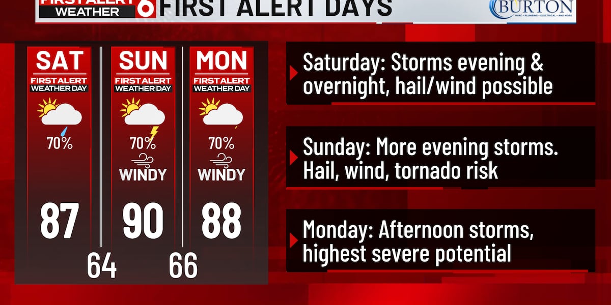
The severe risk on Monday is far greater than our small weekend chances. As a result, Monday is an Alert Day due to the potential for severe thunderstorms during the evening and overnight hours. All hazards will be possible. Now is the time to prepare and change plans if needed.
Showers will likely linger into Tuesday morning, and then we dry out for the rest of the week. Highs will be cooler in the 70s for the remainder of the week starting Tuesday.