



Plus, we have also seen three 90-degree days this month, the highest since 2017, and only the third time since 1959.
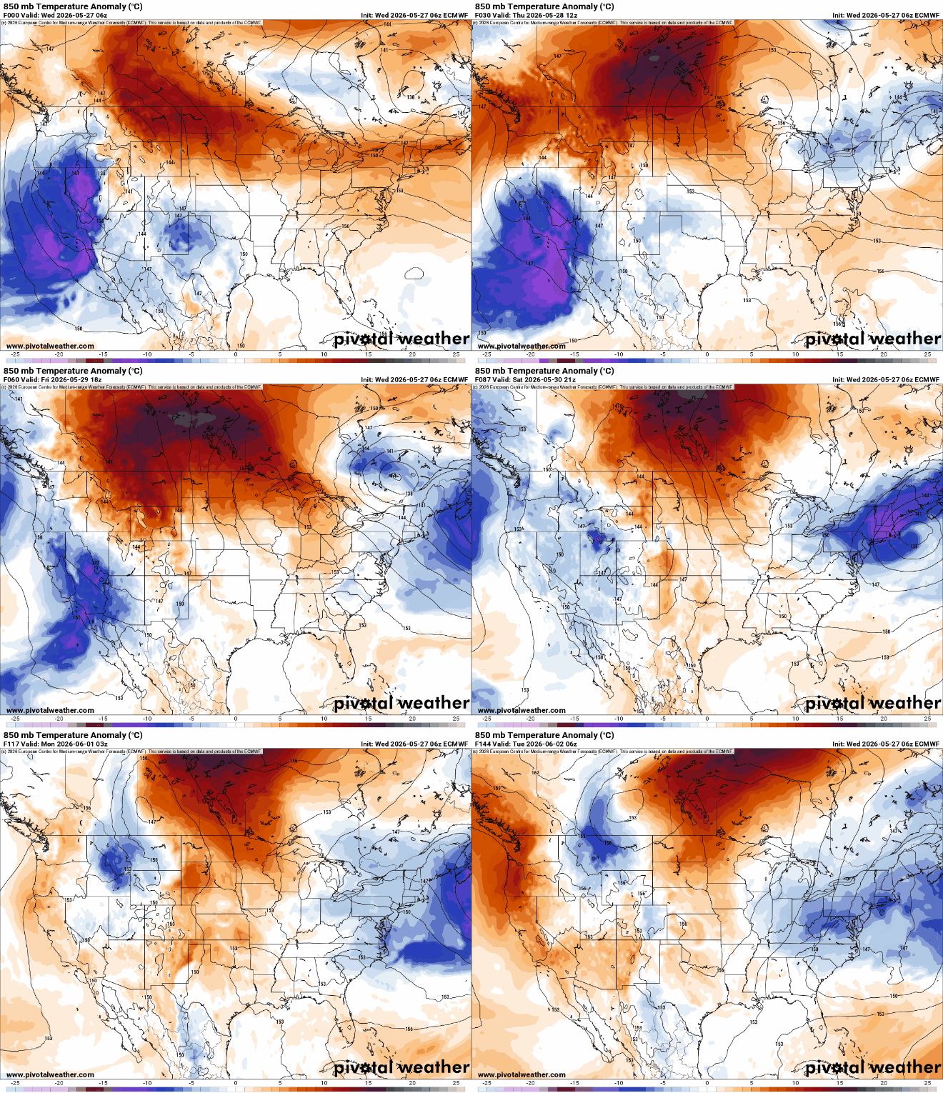
We’ll see how the rest of the month shakes out in terms of heat, but our weather pattern is trending cooler for the next couple of workdays and into the weekend. A massive heat dome over Central Canada has set up what we call an Omega Block, where the jet stream looks like the Greek letter omega, with a trough of cooler weather on both sides. These weather patterns take time to break down as the stalled, stagnant pattern keeps cooler air over the region.
Therefore, New England will see a dip in the jet stream south, setting up temperatures to run five to 10 degrees cooler than average. You can see the pool of cooler (blue) air build over New England from Friday through the start of Tuesday.

Quick look Thursday: transition day, temps start to cool, but still pleasant. Spotty afternoon showers
The headline above speaks volumes for the weather you can expect for Thursday — change. After Wednesday evening’s front passed, we flipped to a northerly flow and will see temperatures struggle to warm on Thursday.
We’ll see more sunshine in the morning than in the afternoon, with some instability leading to popcorn showers across New England during the afternoon. Boston should stay dry for most of the day, but I can’t rule out a quick sprinkle.


Temperatures will be a nudge cooler on Thursday morning’s commute in, ranging between the upper 50s and low 60s. The afternoon will likely reach a pleasant low 70s across the interior, with the coast holding to the upper 60s.

The cooler air naturally settles in up north sooner than the Boston area and Southern New England, so highs across Vermont and east to Maine should range widely in the 60s. Southern New Hampshire may reach 70 degrees briefly.

Thursday evening will cool to the low 50s, so plan to wear a light jacket if you have plans outside after work.
Looking ahead: Rain chances increase for Friday and Saturday
Our next chance for a decent soaking arrives on Friday as a Canadian storm races south into New England, prompting scattered showers to steady rain and even cooler conditions.
Greater Boston should stay dry until around the commute home, but plan to have an umbrella handy for Friday night plans, no matter where you are in New England.

Showers will stick around through most of Saturday, too, as this storm slowly pushes south into the Northern Atlantic.
Do you know how I mentioned the cooler air, too? Well, for portions of Northern New England, Saturday morning lows may hover near the mid-30s, meaning that a few snowflakes are possible for the higher elevations with accumulating snow perhaps at the highest peaks — wow.

All in all, most of the action will be held north of Greater Boston on Friday and Saturday, with folks likely picking up to two inches of rain.
Greater Boston may end up with around a half inch by the time Saturday evening rolls around.

Greater Boston: Sunnier start than finish. Temperatures to the lower 70s in the city, upper 60s along the immediate coast. Scattered light showers possible during the afternoon.
Central/Western Mass.: Mix of sun and clouds with more clouds in the afternoon. A pop-up shower is possible. Highs to the upper 60s in the Berkshires, low 70s east.
Southeastern Mass.: Increasing clouds with highs reaching the upper 60s for most. Spotty afternoon showers likely.
Cape Cod and Islands: Increasing clouds with highs reaching the low and mid-60s. Spotty afternoon showers likely.
Rhode Island: Partly cloudy with highs pushing into the low 70s. Scattered light showers possible during the afternoon and evening.

New Hampshire: Increasing clouds with scattered showers popping up during the afternoon and evening. Highs to the low 60s up north, near 70 south.
Vermont/Maine: Building clouds with highs to the upper 60s in Vermont, upper 50s to upper 60s in Maine, warmest south and by the coast. Scattered showers for both states in the afternoon.
Connecticut: Increasing clouds with highs to the low and mid-70s. Afternoon shower chance.
Sign up here for our daily Globe Weather Forecast that will arrive straight into your inbox bright and early each weekday morning.
Ken Mahan can be reached at ken.mahan@globe.com. Follow him on Instagram @kenmahantheweatherman.
Source link
See more: https://theglobaltrack.com/
https://corinthiames.com.br/