



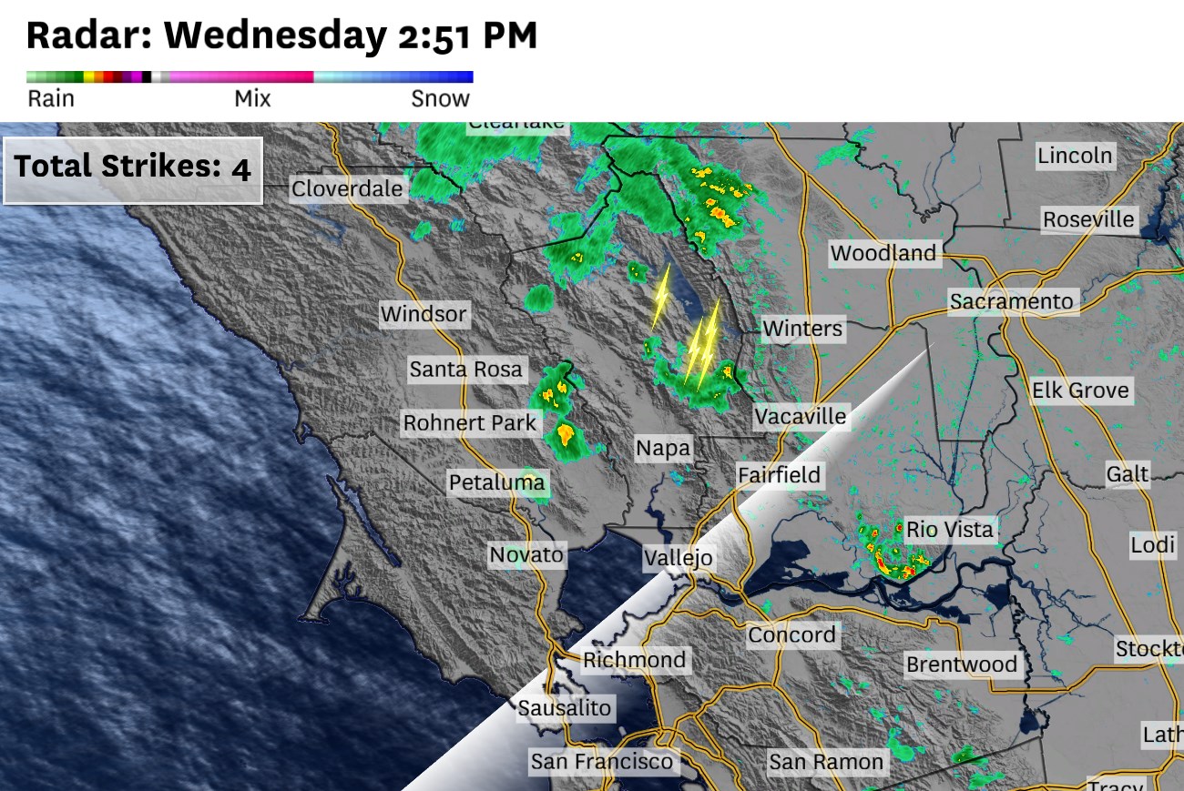
The storm system heading for the Bay Area looked like it’d be a swing-and-a-miss — but is now trending toward a much bigger event that will make for a wet Wednesday night, though there’s still considerable forecast uncertainty.
A swath of moderate rain only 50 to 100 miles wide is expected to move over the Bay Area late Wednesday through Thursday morning. A slight shift in its placement could leave some cities much wetter or drier than forecast. Still, significant rainfall totals are on the table, at least by late May standards.
Thunderstorms already rumbled across the North Bay, Diablo Range and Santa Cruz Mountains on Wednesday afternoon, but precipitation is expected to become more widespread, though less intense, after nightfall.
Steady rain should begin in the North Bay after sunset, then become more widespread across the region after midnight. Light to moderate precipitation is expected to linger through midmorning. Scattered showers may redevelop Thursday afternoon, particularly over the East Bay hills, Diablo Range and Santa Cruz Mountains.
Forecast rainfall totals range from one-tenth to one-quarter inch in San Francisco, Oakland and San Jose. Up to a half-inch is possible in Santa Rosa, Half Moon Bay, the Berkeley Hills, Diablo Range and Santa Cruz Mountains.
Those amounts would be unusual for this time of year. San Francisco averages just 0.02 inches of rain each day in late May. The city hasn’t recorded a day with more than a quarter-inch of precipitation this late into spring since 2011.
Clouds and precipitation will rotate around a counterclockwise-spinning, low-pressure system in the upper atmosphere. The center of rotation is east of the Bay Area, meaning rain will likely move from north to south across much of the region, rather than the more typical west to east direction.
This atypical movement means South Bay and interior East Bay areas that would normally stay dry in the “rain shadow” of the coastal mountains won’t get that protection.
The odd motion also means predicting rainfall amounts is tricky — it’s all part of a discombobulated weather pattern across the Northern Hemisphere right now. A slight wobble in the system could put San Francisco under a swath of a half-inch of rain, or less than one-tenth. And the same goes for the rest of the Bay Area, though the Peninsula has the best chance of the highest totals.
Either way, automatic sprinklers can probably be switched off Wednesday night. A trip to the car wash may not be necessary this week.
Strange weather will linger even after the rain clears Thursday.
High temperatures will be in the upper 60s to low 70s inland, about 5 to 10 degrees below late May norms. Coastal areas, including San Francisco, may be slightly warmer than normal. That’s because the sea breeze is expected to be weak and arrive late in the day, allowing the entire city to warm into the 60s, with low 70s possible east of Twin Peaks.
A few showers are possible overnight Thursday before a warmup begins Friday and lasts through the weekend.
Source link
See more: https://theglobaltrack.com/
https://corinthiames.com.br/