More snow coming: Burst of snow Friday could bring impacts, thundersnow
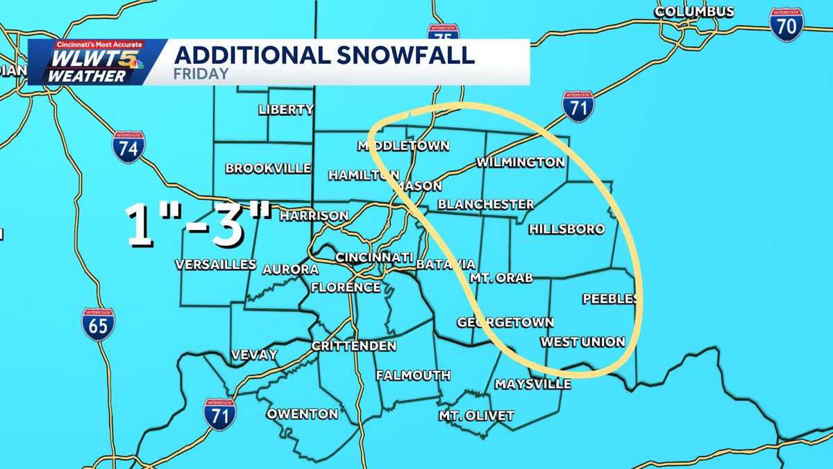
YOU SHOULD GO FIRST. I AGREE WITH THAT. HE SHOULD BE THE ORNAMENT. COLD, OBVIOUSLY. AND MORE SNOW, UNFORTUNATELY. SEEMS LIKE THE SAME SONG WE’VE BEEN HAD HERE THE PAST COUPLE OF WEEKS. IT’S ANOTHER COLD NIGHT OUTSIDE. WE’RE HOLDING AT 19 AT THE MOMENT, SO LET’S TALK ABOUT WHAT’S GOING TO HAPPEN AS WE GO FORWARD INTO YOUR FRIDAY. MAINLY DRY DURING THE MORNING COMMUTE, BUT BETWEEN 7 AND 9 SNOW WILL BEGIN TO SPREAD IN FROM NORTH TO SOUTH, AND THEN IT WILL END IN THE AFTERNOON. AND WELL, BECAUSE WE’LL CLIMB ABOVE FREEZING DURING THE DAY AS ARCTIC AIR ARRIVES, RETURNS TOMORROW NIGHT, YOU HAVE TO WATCH FOR A LITTLE BLACK ICE OUT THERE. SO FRIDAY IS A WEATHER IMPACT DAY ON AVERAGE FOR THE MOST PART, 1 TO 2IN OF SNOW. BUT I’M NOT GOING TO RULE OUT SOMEONE COULD GET AS HIGH AS THREE, ESPECIALLY EAST OF THE METRO HERE. AND THERE WILL BE THE POTENTIAL FOR A LITTLE SLUSH OR EVEN BRIEFLY, SNOW COVERED ROADS AS WE GET THESE SNOW BURSTS COMING THROUGH. IF IT’S HEAVY ENOUGH, IT VERY WELL COULD BRIEFLY AGAIN, THROW SOME SLUSH OUT THERE, OR EVEN BRIEFLY, SNOW COVER ROADWAYS. SO HERE’S 7 A.M. YOU CAN SEE IT’S DRY UNTIL THEN. BUT THEN COMES THE SNOW BEGINNING TO MOVE ITS WAY IN FROM NORTHWEST TO SOUTHEAST ACROSS THE AREA, AND THERE WILL BE SOME DECENT PERIODS OF SNOW THROUGHOUT THE MORNING TOMORROW. NOW, LUCKILY, IT DOESN’T SNOW TERRIBLY LONG. THE SYSTEM IS IN AND OUT, BUT CERTAINLY COULD GIVE US SOME TROUBLE THOUGH. MIDDAY INTO THE EARLY AFTERNOON AND THEN WE’LL GET A BREAK IN. TEMPERATURES LIKELY TIPTOE THEIR WAY TOWARDS FREEZING BEFORE THE ARCTIC AIR ARRIVES DURING THE EVENING, AND BRINGS IN MORE FLURRIES AND SNOW SHOWERS. SO AGAIN, MOSTLY A 1 TO 2 INCH SNOWFALL FOR US. NOW THE WEST OF CINCINNATI YOU GO, THOSE AMOUNTS ARE GOING TO BE EVEN LESS. BUT I WOULDN’T RULE OUT SOMEONE IN THE CIRCLE AREA COULD SQUEEZE OUT THREE INCHES. NOW. DOESN’T MEAN EVERYONE IN THE CIRCLE IS GOING TO GET THREE INCHES OF SNOW. BUT WITHIN THIS AREA, THIS WOULD BE THE BEST CHANCE OF SEEING THAT. SO RADAR, TONIGHT IS QUIET ACROSS THE AREA AS WE KEEP AN EYE ON EVERYTHING COMING TOGETHER. HERE’S A LOOK AT YOUR WINTER WEATHER ADVISORY THAT’S CURRENTLY IN EFFECT FOR THE TRI-STATE. AND WHEN YOU LOOK AT TEMPERATURES, OBVIOUSLY PLENTY COLD TONIGHT TO SUPPORT SOME WINTRY WEATHER TOMORROW, RADAR IS CURRENTLY QUIET, SO THROUGH THE REST OF THE NIGHT, TEMPERATURES HOLD IN THE TEENS PROBABLY ACTUALLY BEGIN TO RISE TOWARDS MORNING IF ANYTHING ELSE. SO 16 WAS THE LOW EARLIER TONIGHT. WE’VE KIND OF HELD AT 19 SINCE MID EVENING. TOMORROW 33. WE’LL SEE IF WE CAN DO IT. BREAK THIS STREAK OF SUBFREEZING DAYS AROUND HERE. WATCH OUT FOR MAYBE A LITTLE SLICK TRAVEL. HERE’S YOUR PLANNER. THERE’S YOUR IMPACT ICONS THROUGH THE FIRST HALF OF THE DAY. AND THEN AGAIN, ARCTIC AIR ARRIVES TOMORROW NIGHT. HERE’S YOUR SEVEN DAY FORECAST. THERE YOU HAVE IT, CHRIS. VERY COLD. FEEL LIKE IT’S BELOW ZERO SATURDAY MORNING. MAYBE SOME PASSING SNOW SHOWERS ON SUNDAY. WE’LL KEEP AN EYE ON THAT. OUR WARM UP I
There’s another clipper system that tries to drop more snow our way Friday morning into the early afternoon. A Winter Weather Advisory begins Friday morning for the entire region.LIVE RADAR // LATEST WEATHER ALERTS // TRAFFIC MAPBefore we make it above freezing, there will be snow.Snow starts around 8 a.m. Friday, first north, then quickly into the metro by 9 a.m. Temperatures will be below freezing as it moves in and head above freezing in the middle of the afternoon. At times, it could be coming down quick enough to cover roads -mainly in the morning and early afternoon. Also there is the possibility for some thundersnow, which would bring a burst of snow to coat the road where it happens.>>Go to the WLWT weather page | Subscribe to WLWT’s YouTube channel Once again, be wary Friday evening/overnight as temperatures drop once the sun sets for slick spots to develop in some of those wet areas: Parking lots, pavement, etc.» Follow WLWT: Facebook | Twitter | InstagramThat clipper acts as a cold front dragging colder air in for Saturday. Temperatures drop in the pre-dawn hours and most of the day temperatures will be in the teens. Wind Saturday morning could be as low as -5, and it will feel like a single digits in the afternoon.Super Bowl Sunday should be around 30 for a high. But there is a warm-up to look forward to next week! High temperatures trending in the 40s maybe even 50s with rain one week from today.
There’s another clipper system that tries to drop more snow our way Friday morning into the early afternoon.
A Winter Weather Advisory begins Friday morning for the entire region.
LIVE RADAR // LATEST WEATHER ALERTS // TRAFFIC MAP
Before we make it above freezing, there will be snow.
Snow starts around 8 a.m. Friday, first north, then quickly into the metro by 9 a.m. Temperatures will be below freezing as it moves in and head above freezing in the middle of the afternoon.
At times, it could be coming down quick enough to cover roads -mainly in the morning and early afternoon. Also there is the possibility for some thundersnow, which would bring a burst of snow to coat the road where it happens.
>>Go to the WLWT weather page | Subscribe to WLWT’s YouTube channel
Once again, be wary Friday evening/overnight as temperatures drop once the sun sets for slick spots to develop in some of those wet areas: Parking lots, pavement, etc.
» Follow WLWT: Facebook | Twitter | Instagram
That clipper acts as a cold front dragging colder air in for Saturday. Temperatures drop in the pre-dawn hours and most of the day temperatures will be in the teens.
Wind Saturday morning could be as low as -5, and it will feel like a single digits in the afternoon.
Super Bowl Sunday should be around 30 for a high. But there is a warm-up to look forward to next week! High temperatures trending in the 40s maybe even 50s with rain one week from today.