ATLANTA – A powerful storm system is bringing the threat of damaging winds and spin-up tornadoes with a sharp drop in temperature to North Georgia early Monday morning.
What they’re saying:
The FOX 5 Storm Team warns that a drastic temperature drop will follow the front, sending wind chills into the teens by Tuesday.
Scattered showers could begin across North Georgia on Sunday afternoon, with temperatures dipping into the 60s. Then, during the overnight hours, comes the powerful storm front.
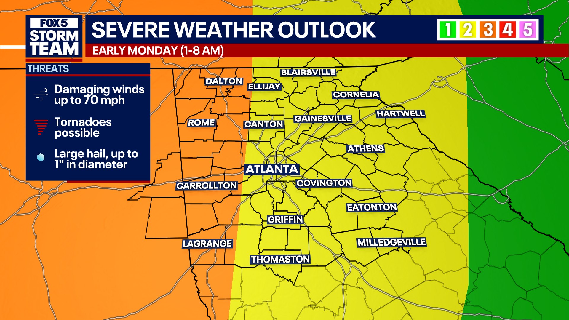
While most of North Georgia is under a Level 2 severe weather threat due to damaging winds and possible tornadoes, parts of western Georgia have been upgraded to a Level 3 risk.
Those in the Level 3 risk zone now include all or part of Paulding, Bartow, Floyd, Coweta, Troup, Heard, Carroll, Douglas, Haralson, Polk, Gordon, Chattooga, Dade, Walker, Whitfield, Catoosa, and Murray Counties.
Timeline:
A powerful line of storms will march across the state beginning in the early morning hours of Monday.
- Sunday afternoon: Scattered storms develop as the main system moves through Tennessee and Mississippi.
- Monday (around 1 a.m.): The main line of severe storms enters Northwest Georgia, moving out of the area around 8 a.m. “It’s not going to storm at your house that entire time, instead it will likely only be about 30-minutes in that window of time,” Forbes said.
- Monday afternoon: Precipitation ends as temperatures begin to drop quickly.
Why you should care:
Regional impacts vary significantly across the area. In the north, Blue Ridge has already seen temperatures fall below freezing while Atlanta remained near 49 degrees to start Saturday. As the front moves through Monday, the FOX 5 Storm Team suggests rainfall will be steady, eventually tapering off to a possible “stray flake” in some areas as the cold air rushes in. No significant accumulation or impact is expected from any wintry mix.

This map shows the severe weather outlook for Sunday, March 15 into Monday, March 16. (FOX 5 News)
The primary hazards with this system involve the potential for property damage and travel disruptions. The FOX 5 Storm Team warns of damaging wind gusts reaching 60 mph, which can down trees and power lines. Additionally, there is a “brief spin-up tornado threat” along the leading line of the storms. Following the rain, the rapid freeze could lead to wind chills in the teens and 20s by Tuesday morning, posing a risk to those unprepared for the sudden return of winter.
“It looks that a tornado or two, somewhere in the southeast, could have enough energy to push EF-2 status before it’s all said and done. Not necessarily a guarantee, but the ingredients will be present for a situation like that,” according to Forbes.
“Warmer, more humid air pulling up from the Gulf means that if any isolated storms form ahead of the main line, they will have a higher potential to produce tornadoes, including the possibility of a strong tornado,” Forbes explained.
What’s next:
After the severe weather threat clears Monday morning, the region will experience a brief but intense “winter chill” for St. Patrick’s Day. This cold snap will be short-lived, with a significant warmup expected by the end of the week just in time for the first day of spring.
The Source: Information in this article came from the FOX 5 Storm Team and the National Weather Service.