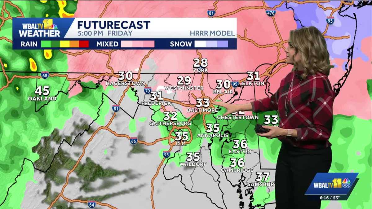
BUT TOMORROW IS AN ALERT DAY BECAUSE OF THE ICY MIX THAT WILL DEVELOP IN THE AFTERNOON AND EVENING. SO WE EXPECT DRY WEATHER TONIGHT. STILL DRY TOMORROW MORNING, BUT ANY TIME AFTER NOON TOMORROW, THAT’S WHEN WE COULD BE LOOKING AT SOME SNOW, SLEET AND THEN EVENTUALLY ALL BECOMING A FREEZING RAIN AND RAIN. THE PROBLEM IS THAT FREEZING RAIN COULD LOOK LIKE EVERYTHING’S WET, YET EVERYTHING CAN BE VERY ICY, SO IT’S SOMETHING WE’LL HAVE TO WATCH REALLY CLOSELY WHEN WE GET INTO THAT POSSIBILITY OF SLICK SURFACES LATER TOMORROW. I’LL BE WATCHING THE TEMPERATURES VERY CLOSELY. THEY ARE RIGHT NOW REALLY MILD. WE ARE CURRENTLY IN THE LOW 50S IN MANY SPOTS. IT WAS SO NICE TO HAVE THE SUN AND TEMPERATURES A LOT WARMER. WE CAN SEE A 53 RIGHT NOW IN DOWNTOWN BALTIMORE. SO THE TEMPERATURES AS WE LOOK AT THEM HEADING INTO THE NIGHT, WELL, IT’S GOING TO BE DROPPING FROM THE 40S DOWN INTO THE 30S, EVENTUALLY INTO THE 20S. AND WE’LL HAVE INCREASING CLOUDS LATE TONIGHT THROUGH EARLY TOMORROW MORNING. IT WILL STILL BE DRY IN THE MORNING. SO IF YOU HAVE TO GET BACK OUT AND RUN SOME ERRANDS, THAT WOULD BE A BETTER TIME TO DO IT. LATE TONIGHT, 28 IN BALTIMORE, 24 FOR YORK AND 27 TONIGHT IN EASTON. THE STORM SYSTEM WILL BE DEVELOPING FROM THE WEST BY TOMORROW, BUT SOMETHING TRICKY IS HAPPENING. ALTHOUGH THE PRECIPITATION IS COMING FROM THE WEST, THE COLD AIR IS SPILLING IN FROM THE NORTH AND EAST. THIS IS A COMMON SCENARIO THAT SETS UP TO THE EAST OF THE APPALACHIANS. THAT COLD AIR THEN GETS STUCK NEAR THE SURFACE. SO EVEN AS WARM AIR COMES OVERHEAD, WE GET WHAT HAPPENS IS A LAYER OF SOME COLD AIR THAT CREATES FREEZING PRECIPITATION. SO LOOK AT MIDDAY TOMORROW. MAYBE SOME FLURRIES ARE STARTING TO BREAK OUT. THE FIRST OF THE FREEZING RAIN ACROSS WESTERN MARYLAND. YOU START TO SEE SOME MORE PINK AND PURPLE ON THE MAP HERE BY FRIDAY AFTERNOON. SO THIS COULD BE SOME LIGHT SNOW OR SLEET CHANGING OVER TO THAT FREEZING RAIN ANYWHERE SOUTH OF BALTIMORE. IT COULD BE MORE OF A RAIN WHERE THE TEMPERATURES ARE ABOVE FREEZING, BUT EVEN ANNAPOLIS AND CHESTERTOWN WILL BE TEETERING RIGHT NEAR FREEZING, SO A LITTLE BIT OF ICE COULD DEVELOP THERE AS WELL. BY THE MIDDAY 5:00, THINGS ARE GETTING WORSE. YOU CAN SEE MORE PINK ON THE MAP, SO IT’S LEANING MORE TOWARDS THAT FREEZING RAIN. IT LOOKS LIKE LIQUID, YET IT’S CAUSING A GLAZE OF ICE ON MANY SURFACES WHERE THE AIR TEMPERATURE IS BELOW FREEZING. 29 WESTMINSTER 30 IN BEL AIR, 31 IN ELKTON AT 5:00 IN THE AFTERNOON. SO THAT’S CAUSING ACCUMULATING ICE. THE THICKEST ICE COULD BE OUT TOWARDS ALLEGHENY COUNTY, WHERE IT COULD BE AN ALL OUT ICE STORM, ENOUGH TO MAYBE BRING DOWN POWER LINES HERE. THE PRIMARY CONCERN IS THAT THE ICE COATS SURFACES, SO IT’S STILL COATING SURFACES AROUND 9:00. AND THEN LOOK HOW THE PRECIPITATION STARTS TO BREAK UP THROUGHOUT THE EVENING TOMORROW. BUT UNTIL THE TEMPERATURES WARM ABOVE FREEZING, YOU’RE GOING TO WANT TO WATCH OUT FOR SLICK SURFACES, BECAUSE LOOK AT THE HIGHS FOR TOMORROW. WESTMINSTER IS AT OR BELOW FREEZING ALL DAY. SAME CASE IN YORK. WE TEETER RIGHT NEAR FREEZING IN ABERDEEN AND BALTIMORE CITY. NOW PLACES SOUTH LIKE ANNAPOLIS AND EVEN FROM CHESTERTOWN SOUTH TO EAST. AND IT SHOULD EVENTUALLY WARM ABOVE FREEZING LATE FRIDAY. SO EVEN IF IT GETS ICY MIDDAY, IT SHOULD IMPROVE LATER FRIDAY INTO FRIDAY NIGHT. SO THE MAIN CONCERN IS ANYTIME AFTER NOON TOMORROW, WHEN THAT WINTRY MIX DEVELOPS, IF THERE’S ANY SNOW AND SLEET, IT’S GOING TO BE AN INCH OR LESS, BUT THEN IT COULD COAT IN THAT GLAZE OF ICE THROUGHOUT THE EVENING TOMORROW. SO JUST BE VERY CAREFUL. IT’S PROBABLY A BETTER SITUATION TO STAY IN IF YOU CAN, BUT IF YOU HAVE TO VENTURE OUT, THE MAIN ROADS SHOULD BE BETTER WHERE THEY’RE ABLE TO PUT SALT DOWN. SEVEN DAY FORECAST. SO ONCE WE GET THROUGH THAT ICY MIX ON FRIDAY NIGHT, THERE COULD STILL BE SOME DRIZZLE AROUND SATURDAY MORNING. SO JUST BE CAREFUL IN THOSE NORTHERN AREAS. IT MAY TAKE A FEW HOURS AFTER SUNRISE SATURDAY FOR EVERYTHING TO COMPLETELY MELT, THEN 40 DEGREES FOR HIGHS. THIS WEEKEND. WE’LL HAVE MORE RAIN DEVELOPING LATER ON SUNDAY. IT’S RAINY ON MONDAY OUT OF THAT IMPACT ICON TO LET YOU KNOW THE WINDS PICK UP. THERE COULD BE SOME GUSTS
Alert Day Friday: Sleet, freezing rain afternoon, evening in parts of Maryland

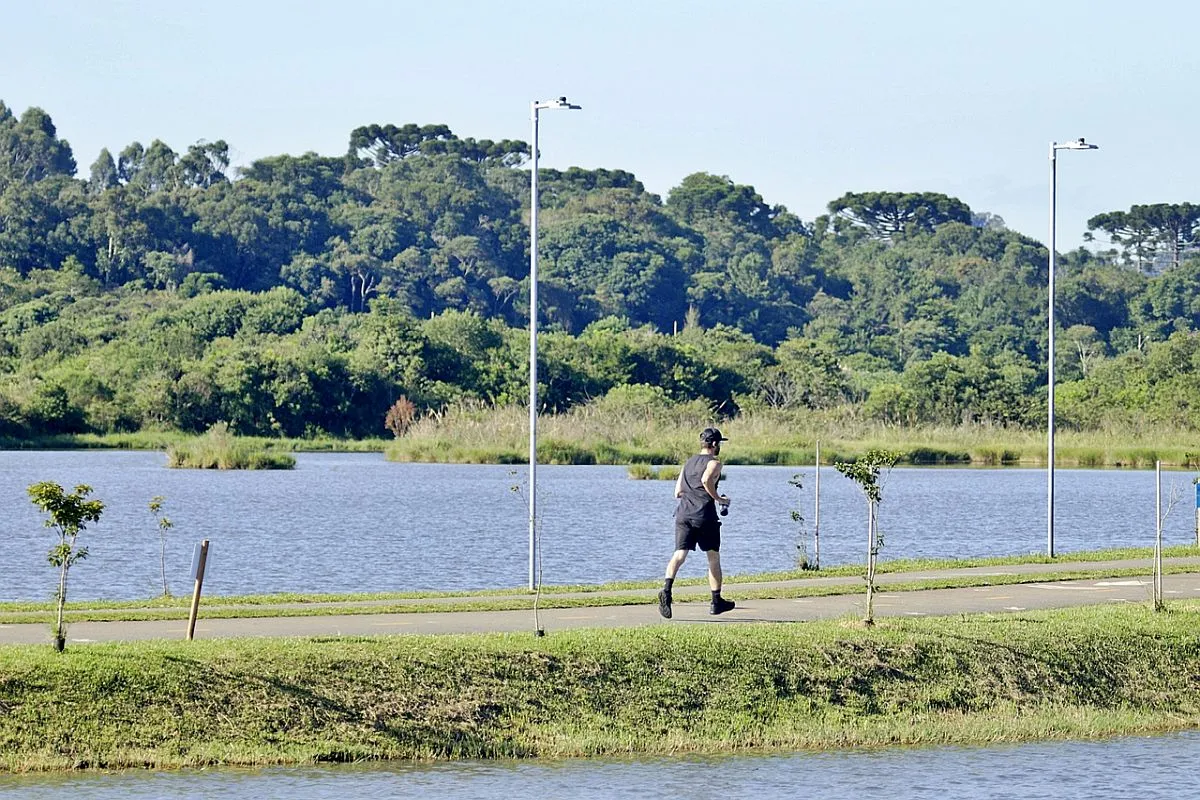
The Baltimore region will likely see a wintry mix Friday afternoon.|| Closings/Delays | Weather Advisories | Radar | Forecast | Email Alerts | Send us your pics ||ALERTS: A winter weather advisory is in effect from 10 a.m. to 11 p.m. Friday for most of Maryland north and west of the Interstate 95 corridor.WHAT: A combination of snow, sleet, freezing rain and rain. Temperatures will hover at or near freezing all day, especially in the northern suburbs.Meteorologist Ava Marie is tracking an icy mix of precipitation that will develop Friday afternoon. It will start mixed with some snow and sleet, and then it will change to more of a freezing rain and rain, coating many surfaces in a glaze of ice.WHERE: The ice will be worse and last longer for areas north of Baltimore, where temperatures stay below freezing longer.HOW MUCH: Less than an inch of snow and sleet accumulation is possible with up to a tenth of an inch of ice accumulation is possible.HOW LONG: Icy spots could remain into Saturday morning in the northern suburbs, until temps warm above freezing after sunrise SaturdayThe precipitation will taper Friday night, but areas of drizzle are possible into early Saturday morning.| LINK: MDOT SHA’s Statewide Transportation Operations Response Map Download the WBAL-TV app NOW and turn on push alerts to be aware of severe weather warnings, listen to NOAA Weather radio, and watch WBAL-TV 11 when impending severe weather develops.@wbaltv11 | @TTasselWBAL | @AvaWBAL | @TonyPannWBAL | @DalenciaWBAL | @AlenaLeeWXWBAL-TV 11 Maryland Weather RadarApp users tap here for interactive radar.Maryland’s 7-Day Weather ForecastAlert Days vs. Impact DaysYou may see the WBAL-TV 11 Weather Team highlight Alert Days or Impact Days in the forecasts. Here’s what that means:An Impact Day is when weather will likely disrupt your normal daily schedule or routine.An Alert Day is when there’s a threat of extreme, severe and possibly life-threatening weather.Potential power outagesStorm conditions could cause outages by knocking down tree limbs onto power lines and other electric delivery equipment. Baltimore Gas and Electric asks all customers to report their outage in any of the following ways: Online, at BGE.comBGE’s free mobile app, available at the Apple Store or Google Play Text message, to 69243 Phone, by calling 877-778-2222The latest outage information, including total number and general locations, is available on the BGE.com outage map.As a reminder, fallen overhead power lines should never be approached or touched even if the lines do not appear to be live or sparking. Call BGE at 877-778-2222 to report fallen electrical lines, power outages and gas odors.Share your weather photos and videosWhen and where safe, show us your weather photos and videos, we may show them on 11 News or online!DIRECT UPLOAD: Use this form to upload photos or video.EMAIL: Just email your photos and video to news@wbaltv.com.ALERTS: Severe weather alerts from the WBAL-TV app: step-by-step guideCLOSINGS: See if schools, businesses or organizations have closed or delayedRADAR: Track snow, sleet or freezing rain with WBAL-TV’s interactive radarROADS: Check for crashes and backups with our interactive traffic mapWINTER: Guide: Snow safety, driving hazards, power outagesTORNADO SURVIVAL: 5 things you need to do nowHURRICANE PREPARATION: How to prepare for hurricane season
The Baltimore region will likely see a wintry mix Friday afternoon.
|| Closings/Delays | Weather Advisories | Radar | Forecast | Email Alerts | Send us your pics ||
ALERTS: A winter weather advisory is in effect from 10 a.m. to 11 p.m. Friday for most of Maryland north and west of the Interstate 95 corridor.
WHAT: A combination of snow, sleet, freezing rain and rain. Temperatures will hover at or near freezing all day, especially in the northern suburbs.
Meteorologist Ava Marie is tracking an icy mix of precipitation that will develop Friday afternoon. It will start mixed with some snow and sleet, and then it will change to more of a freezing rain and rain, coating many surfaces in a glaze of ice.
WHERE: The ice will be worse and last longer for areas north of Baltimore, where temperatures stay below freezing longer.
HOW MUCH: Less than an inch of snow and sleet accumulation is possible with up to a tenth of an inch of ice accumulation is possible.
HOW LONG: Icy spots could remain into Saturday morning in the northern suburbs, until temps warm above freezing after sunrise Saturday
The precipitation will taper Friday night, but areas of drizzle are possible into early Saturday morning.
| LINK: MDOT SHA’s Statewide Transportation Operations Response Map
Download the WBAL-TV app NOW and turn on push alerts to be aware of severe weather warnings, listen to NOAA Weather radio, and watch WBAL-TV 11 when impending severe weather develops.
@wbaltv11 | @TTasselWBAL | @AvaWBAL | @TonyPannWBAL | @DalenciaWBAL | @AlenaLeeWX
WBAL-TV 11 Maryland Weather Radar
App users tap here for interactive radar.

Maryland’s 7-Day Weather Forecast

Alert Days vs. Impact Days
You may see the WBAL-TV 11 Weather Team highlight Alert Days or Impact Days in the forecasts. Here’s what that means:
- An Impact Day is when weather will likely disrupt your normal daily schedule or routine.
- An Alert Day is when there’s a threat of extreme, severe and possibly life-threatening weather.
Potential power outages
Storm conditions could cause outages by knocking down tree limbs onto power lines and other electric delivery equipment. Baltimore Gas and Electric asks all customers to report their outage in any of the following ways:
The latest outage information, including total number and general locations, is available on the BGE.com outage map.
As a reminder, fallen overhead power lines should never be approached or touched even if the lines do not appear to be live or sparking. Call BGE at 877-778-2222 to report fallen electrical lines, power outages and gas odors.
Share your weather photos and videos
When and where safe, show us your weather photos and videos, we may show them on 11 News or online!
Source link
See more https://theglobaltrack.com/