Multiple rounds of storms moving through today and again on Saturday could bring gusty winds and heavy downpours to our area.
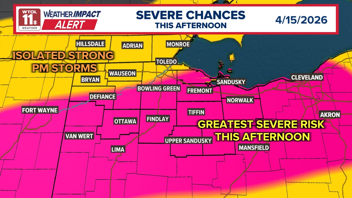
TOLEDO, Ohio — A Weather Impact Alert Day is in effect today for the potential of additional strong to severe thunderstorms across northwest Ohio. Several rounds of rain and storms are expected, bringing the threat for flooding downpours, gusty winds, and travel impacts.
WHEN
Scattered showers and downpours are already moving through the area as of 10:30 a.m., with additional storms expected to redevelop this afternoon, especially across parts of northwest Ohio.
Storm chances will continue into the overnight hours, although those are expected to be non-severe. After a quieter and warmer day Friday, attention turns to Saturday, when another round of storms is likely. A second Weather Impact Alert Day has been issued for Saturday as some storms could again become strong or severe.
IMPACT
This morning’s rain may lead to flooding on roadways and in some basements, creating issues for travel. As the day progresses, stronger storms this afternoon could bring gusty winds and torrential downpours.
- Localized flooding from heavy rainfall
- Reduced visibility and ponding on roads
- Strong wind gusts with afternoon storms
- Large hail could cause some damage
While storms tonight are expected to weaken, the pattern remains active heading into the weekend. Saturday’s storms could bring another round of strong or severe weather, followed by a noticeable change.
Behind Saturday’s cold front, temperatures will drop significantly, with highs falling to near 50 degrees on Sunday. Cooler conditions will continue into next week, marking a shift away from the recent summer-like warmth.
NEED
Residents should remain weather aware throughout the day, especially during the afternoon when stronger storms are more likely to develop. Be cautious if traveling during heavy rain, as water may quickly accumulate on roads.
- Avoid driving through flooded roadways
- Allow extra time for travel during downpours
- Stay updated on forecast changes, especially ahead of Saturday
Even though Friday will bring a break with sunshine and highs in the 70s, the active pattern returns quickly. Make sure to stay prepared for additional storms and changing conditions into the weekend.