While we don’t expect any severe weather, heavy rain could cause problems on the road.
HOUSTON — The KHOU 11 Weather Team is issuing an hourly Weather Impact Alert for the Houston area on Friday, April 10. According to Chief Meteorologist David Paul, periods of heavy rain are expected to move through the region during the day.
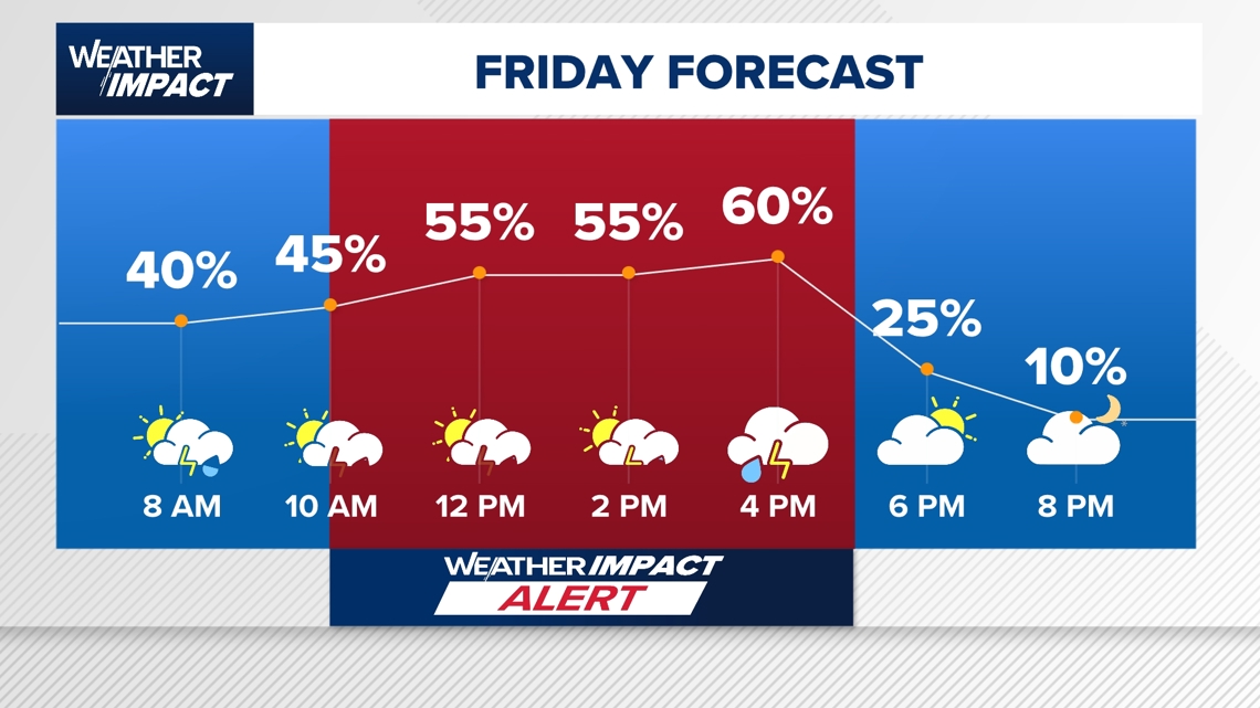
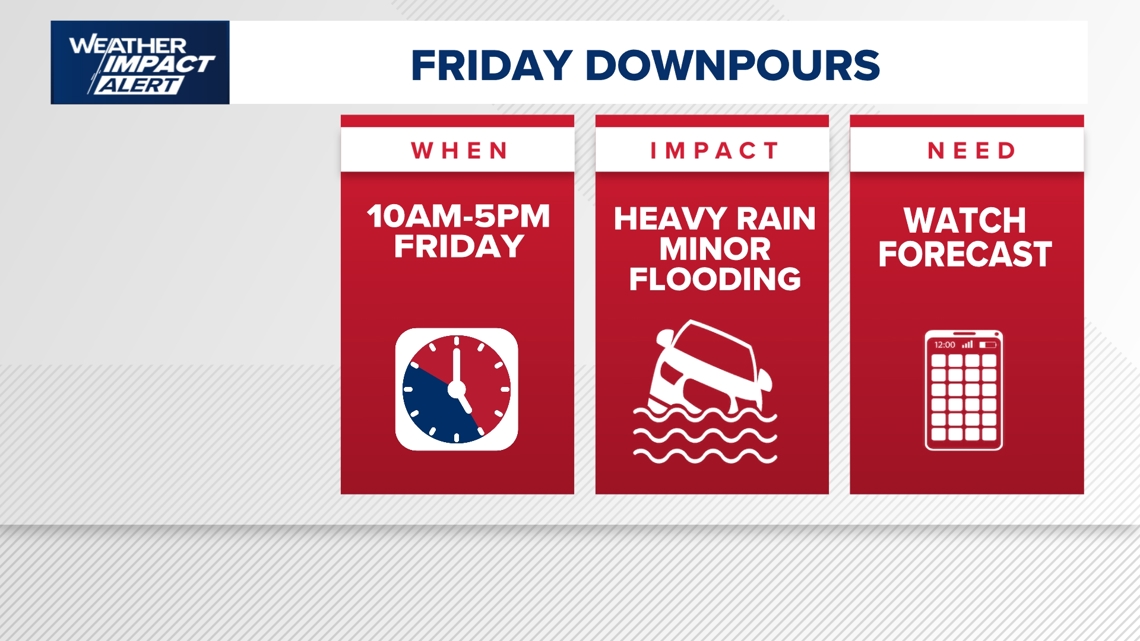
Rain chances are ramping up across the Houston area today, with a Weather Impact Alert in effect from 10 a.m. to 5 p.m. as periods of heavy rain move through the region.
While no severe weather is expected, the KHOU 11 Weather Team says some downpours could be intense at times and may lead to localized issues.
What’s the threat today?
Primary concern: Heavy rain and thunderstorms
- Localized high water spots
- Very isolated street flooding
- No widespread flooding threat
- No severe weather risk at this time
Even without a severe weather setup, steady rain over several hours could create brief travel issues, especially in typical low-lying areas.
Timing: When to expect rain
Rain chances will build as the day goes on, with the heaviest activity expected midday:
Morning (before 10 a.m.): Mostly quiet start
Late morning (around 10 a.m.): Rain begins to increase
Midday to early afternoon (noon–2/3 p.m.):
- Peak rain window with heavier downpours
- Widespread coverage across the Houston area
Late afternoon (through 5 p.m.): Rain chances gradually taper
The KHOU 11 Weather Team says there may be little break in activity during the peak window, especially around lunchtime.
Who will see the most rain?
Harris County and central Houston: Highest coverage of rain
Major corridors affected:
- North Freeway (I-45)
- Katy Freeway (I-10)
Storms are expected to be widespread across the metro, not isolated to one area
What this means for you
- Midday commute & lunch plans: Expect wet roads and possible slowdowns
- Outdoor activities: Plan for interruptions, especially late morning through early afternoon
- Drivers: Watch for water collecting on roads in typical trouble spots
Even though flooding is not expected to be widespread, Houston’s streets can flood quickly under heavy rain, so stay alert.
Bonus: Pollen relief arrives
There’s some good news mixed in with the rain — pollen levels are finally dropping after weeks of high counts.
- Oak pollen has moved past its peak
- Mold levels are moderate
- Grass and weed pollen remain low
Looking ahead
- Saturday: Fewer rain chances, mainly isolated showers (especially west of Houston)
- Sunday: Even drier, with only a slight chance of isolated rain
- Next week: Daily rain chances continue, with temperatures warming into the mid-80s
Bottom line: Today is your main weather impact day, with the highest rain chances centered around midday. Keep an eye on the radar and plan accordingly.
Counties we serve:
Harris County (including Houston, Pasadena, Baytown), Fort Bend County (Richmond, Sugar Land, Missouri City), Montgomery County (Conroe, The Woodlands), Brazoria County (Angleton, Pearland, Alvin, Lake Jackson), Galveston County (Galveston, League City, Texas City), Liberty County (Liberty, Cleveland, Dayton), Walker County (Huntsville, New Waverly), Waller County (Hempstead, Prairie View, Waller), Polk County (Livingston, Corrigan), Chambers County (Anahuac, Mont Belvieu, Winnie), Wharton County (Wharton, El Campo), Washington County (Brenham), Matagorda County (Bay City, Palacios), Grimes County (Anderson, Navasota), Austin County (Bellville, Sealy), Colorado County (Columbus, Eagle Lake, Weimar), Trinity County (Groveton, Trinity).