Wildfires in Nebraska are causing smoke to drift into northeastern Colorado. High winds and dry weather persist across the region before snow and record heat.
DENVER — Winds are blowing wildfire smoke from Nebraska into northeastern Colorado on Friday morning.
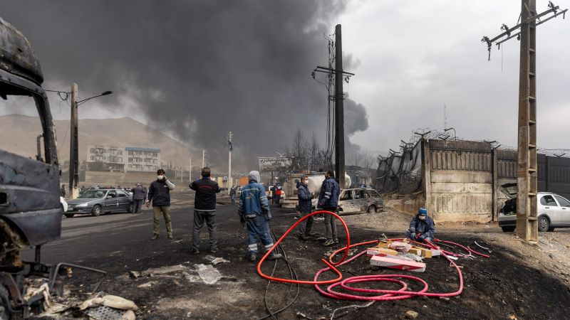
A large wildfire in central Nebraska forced people out of their homes late Thursday and early Friday. The National Weather Service in Hastings issued the evacuation order for the town of Farnam and southwest Dawson County in Nebraska.
The 9NEWS Weather Impact Team said that the winds shifted Friday morning in northeastern Colorado, dragging in the smell of smoke blowing from the east.
The National Weather Service said smoke from the Nebraska wildfires has moved over northeast Colorado, including the Hudson/Greeley area.
The Greeley Fire Department said Friday that it has received many reports of smoke in the area and confirmed that there are no active fires within the city.
“Reports from neighboring jurisdictions are saying that the dense smoke in our area is coming from wildfires burning to the East and North of our community,” the Greeley Fire Department said. “We can confirm that, at this time, there are no active fires burning within city limits. Please take precautions if you are sensitive to poor air quality like using a filtered mask, staying indoors, and limiting physical exertion outside until the air quality improves. If you see flames or a new column of smoke, please call 911 to report.”
The Colorado Department of Public Health and Environment (CDPHE) issued a Air Quality Health Advisory for wildfire smoke at 7 a.m. Friday.
“Smoke from out-of-state wildfires will impact the advisory area on Friday. Conditions will improve Friday morning across northeastern Colorado, but smoke could linger into the afternoon across southeastern Colorado,” CDPHE said.
The advisory is the eastern Colorado countines of Larimer, Weld, Morgan, Logan, Sedgwick, Phillips, Washington, Yuma, Lincoln, Kit Carson, Cheyenne, Crowley, Otero, Kiowa, Bent, Prowers and Baca Counties.
Locations include Fort Collins, Greeley, Fort Morgan, Sterling, Julesburg, Holyoke, Akron, Wray, Limon, Burlington, Cheyenne Wells, Ordway, La Junta, Eads, Las Animas, Lamar and Springfield, CDPHE said.
“If smoke is thick or becomes thick in your neighborhood you may want to remain indoors, especially for those with heart disease, respiratory illnesses, the very young, and older adults,” the advisory said. “Consider limiting outdoor activity when moderate to heavy smoke is present. Consider relocating temporarily if smoke is present indoors and is making you ill. If visibility is less than 5 miles in smoke in your neighborhood, smoke has reached levels that are unhealthy.”

The high winds and dry weather will continue in Colorado on Friday and Saturday.
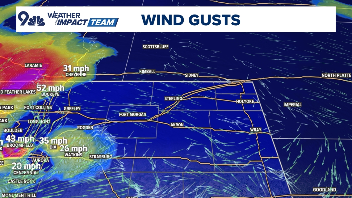
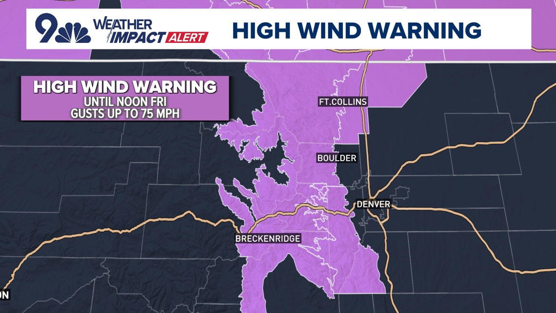
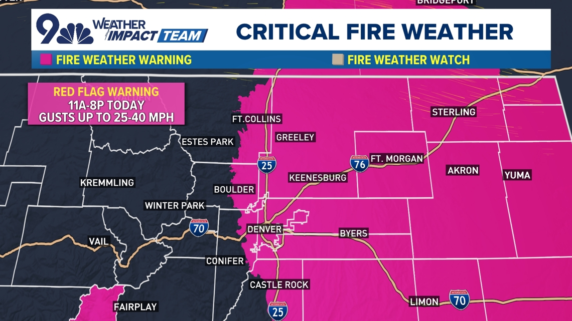
High Wind Warnings are in place for the Colorado mountains and foothills above 7,000 feet for Friday, and Fire Weather Warnings are in effect for Denver and the entire metro area for Friday as well. These warnings will continue into Saturday.
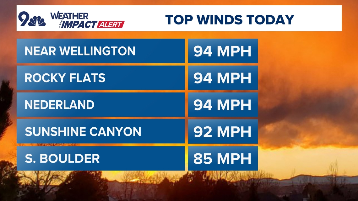
The foothills will be windiest on Friday morning, with 60-80 mph gusts likely. In Denver, winds will start on a quieter note on Friday before revving up during the day Friday. Gusts of 30-40 mph are likely in Denver, so not as windy as Thursday.

More wind Saturday
A more widespread windy day is in store for Saturday, with 40-60 mph widespread winds likely, with a brief surge of 60-70 mph gusts possible on Saturday night ahead of a powerful cold front. Temperatures in Denver top out in the low 70s on Friday and mid-70s on Saturday.
Then, a sharp cold front pushes through the Front Range on Saturday night and Sunday morning, likely leading to mountain snow squalls on Saturday evening. That could mean tough travel, especially after dark on Saturday.
Denver will drop from the mid-70s on Saturday afternoon down into the 20s by Sunday morning, with a few snow showers likely and a dusting-2 inches of snow possible around the metro area. The best odds for accumulating snow will be south and west of Denver, in the foothills and on the Palmer Divide.
Then, a historic March heat wave looms for Colorado, with near 90-degree temperatures possible in Denver later next week and weekend. That would break the city’s all-time warmest March high temperature record by a wide margin, with the current mark being 84 degrees on March 26, 1971. Get ready for a wild stretch of Colorado weather, starting with wind and ending with record heat next week.


Denver Forecast
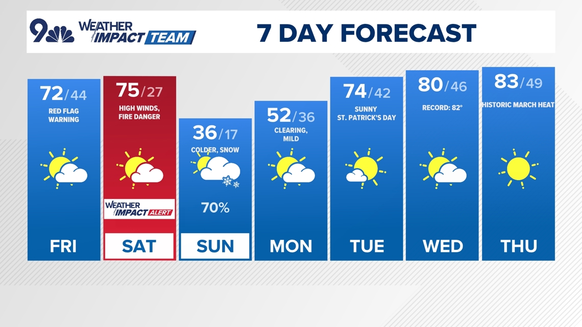
- FRIDAY: Mostly sunny, breezy and warm. High 72, low 44.
- SATURDAY: Partly cloudy, warm. High winds. High 75, low 27.
- SUNDAY: Partly cloudy and colder. Chance for ssnow. High 36, low 17.
- MONDAY: Partly cloudy and mild. High 52, low 36.
- TUESDAY: Partly cloudy and warmer. High 74, low 42.
- WEDNESDAY: Partly cloudy and warmer. High 80, low 46.
- THURSDAY: Mostly sunny with record heat likely. High 83, low 49.

RADAR: Live Interactive Radar
CLOSINGS: Latest closings and delays in Colorado
WEATHER LINE 9: Updated weather forecast information at 303-871-1492.
TRAFFIC CENTER: Keep up on crashes and travel times here
If you have a weather report, photo or video to share, you can contact the 9NEWS Weather Team in these ways:
EMAIL: Weather photos, videos
Share updates on our Facebook wall: facebook.com/9weather
Tweet your updates using the hashtag #9WX or tweet us at twitter.com/9NEWSWeather
iTunes: on9news.tv/itunes
Google Play: on9news.tv/1lWnC5n
9NEWS Weather Impact Team
The 9NEWS Weather Impact Team of Kathy Sabine, Chris Bianchi, Katie LaSalle, Cory Reppenhagen, Keely Chalmers, Jaden Knowles, Carly Cassidy and Chris Spears updates the Denver weather forecast multiple times each day.
Bookmark this link to always have the latest forecast from 9NEWS. The team values your local weather reports and often features your photos and videos during weather segments in all newscasts.