




How to properly display an American flag on Memorial Day
Veterans groups explain Memorial Day flag etiquette rules and common mistakes Americans make when displaying the U.S. flag.
As Memorial Day observances take place on May 25, participants in parts of the eastern half of the United States could be dodging showers and thunderstorms, while the west remains mostly dry and hot.
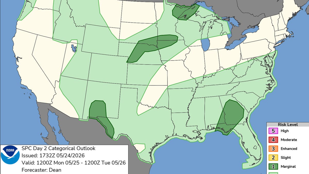
Much of the Central and Southeastern United States faces a risk of showers and thunderstorms on Memorial Day, the National Weather Service said in a May 24 forecast.
Low pressure and plenty of moisture along a slow-moving front will lead to the wet and active weather, with multiple rounds of showers and thunderstorms forecast for May 25 from the Lower Mississippi Valley, Mid-South, and Southeast, to the Ohio Valley, Mid-Atlantic, and Northeast. That includes more than 10 million people who could face a level two out of five risk of severe thunderstorms, including parts of New Mexico, Texas, Florida, Georgia, Nebraska, South Dakota, and Minnesota.
The heaviest swath of rainfall and potential flash flooding is forecast from southeastern Louisiana into Tennessee and the Carolinas.
Meanwhile, a high-pressure area is expected to keep much of the Western United States mostly dry and warmer than normal, the weather service said. The hottest temperatures are forecast in the desert valleys of California, Nevada, and Arizona, where the highs could climb into the 100s early in the week.
The Pacific Northwest, however, could see some precipitation as Memorial Day progresses. Showers are possible, with snow potentially falling in the highest elevations of the Cascades.
Droughts worsen
The U.S. Drought Monitor released May 21 shows the area of the country experiencing severe or greater drought has doubled over the last three months, rising from 22% to 44%, said Alan Gerard, a retired federal meteorologist who publishes the Balanced Weather blog on Substack. As a result, the Drought Severity and Coverage Index has reached 206, its highest point since 2012, surpassing a summer-to-autumn drought in 2023, Gerard wrote.
Flash flooding in the South
The forecast thunderstorms could be a mixed blessing for parts of the South.
After months of drought, the South is in dire need of rain, but lightning or rain that falls too fast could create additional problems, sparking fires or causing flash flooding. Flash flooding was reported on May 24 in southeast Texas in the Houston and Galveston weather service region.
On May 24, nearly 17 million people from Texas to West Virginia were under a flood watch.
In an X post on May 24, the weather service office in New Orleans reported that Gulfport, Mississippi, had received 7.19 inches of rain over three days, while Houma, Louisiana, had seen 4.09 inches, and New Orleans reported slightly more than 3 inches.
Gerard also wrote on Substack that an upper-air pattern called an omega block appears to be setting up, with a high-pressure area over parts of the Central United States and an active area to the south that will use very moist air to produce rounds of thunderstorms with “torrential downpours.”
Chilly waters in Maine
In Maine, the weather service office in Gray warned of dangerous, unseasonably cold waters that could trick swimmers into not realizing just how frigid the water is.
Water temperatures are only in the mid-50s across Sebago Lake and Lake Winnipesaukee, and in the mid-50s in lakes and rivers elsewhere in the region. If a person falls off a boat when the water temperatures are below 60 degrees, it can quickly lead to hypothermia, the weather service warned.
“Anyone on small boats, canoes, or kayaks should plan accordingly … and use extreme caution,” the weather service advised.
Dinah Voyles Pulver, a national correspondent for USA TODAY, covers climate change, weather, the environment and other news. Reach her at dpulver@usatoday.com or @dinahvp on Bluesky or X or dinahvp.77 on Signal.
Source link
See more: https://theglobaltrack.com/
https://corinthiames.com.br/





![[[“LIVESTREAM”]]PPV!] Will Ospreay vs Samoa Joe Live Free Wrestling 24 May 2026](https://www.ubirataonline.com.br/wp-content/uploads/2026/05/LIVESTREAMPPV-Will-Ospreay-vs-Samoa-Joe-Live-Free-Wrestling-24.jpeg)