UPDATES | Winter Storm Warning in effect as significant snow moves in
NEWS FIVE SEAN, ILLUSTRATING WHAT WE’RE CONCERNED ABOUT TODAY INTO TOMORROW. THE DANGEROUS ROADS OUT THERE. AND ACTUALLY, WE’RE ALREADY SEEING IT JUST IN THE LAST COUPLE OF MINUTES BRINGING IN OUR METEOROLOGISTS, ALLISON ROGERS AND SABRINA BATES. GUYS, YOU WERE JUST SHOWING ME SOME PICTURES. THERE’S AN ACCIDENT ON 71 RIGHT NOW. YEAH. AND THIS IS SOMETHING THAT WE’VE BEEN CONCERNED ABOUT MOVING FORWARD INTO TONIGHT AS THAT SUN SETTING. IT’S REALLY COLD OUT. THE SNOW IS GETTING HEAVIER. THESE ROADS ARE STARTING TO WORSEN. AND THAT’S SOMETHING. YEAH THEY’RE GETTING SLICK. THAT’S SOMETHING THAT WE’RE GOING TO BE SEEING HERE THROUGHOUT THE OVERNIGHT AND WORSENING BY TOMORROW MORNING. SO HERE’S I-71 OVER AT MLK. SO JUST NORTH OF DOWNTOWN. AND YOU CAN SEE THAT EMERGENCY RESPONDER RESPONDING TO THE SCENE. AND AGAIN SOMEBODY OUT OF THEIR CAR EARLIER. BUT NOW WE’RE LOOKING AT A VERY BUSY RADAR TOO. AND THAT SNOW COVERED ROADS THOSE ARE CONTINUING TO WORSEN. HEAVY SNOW MOVING ACROSS THE CINCINNATI METRO AS WE SPEAK. IT’S COMING DOWN VERY HEAVILY THERE, NORTHERN KENTUCKY AND THEN PORTIONS OF SOUTHEASTERN INDIANA AS WELL. WYOMING, FINNEYTOWN FOREST PARK, COLERAIN, CHEVIOT, EAST SIDE, WEST SIDE. DOESN’T MATTER. WE’RE ALL SEEING THAT HEAVY SNOW COMING DOWN AT THIS POINT, ALSO IMPACTING COVINGTON, VILLA HILLS, LAKESIDE PARK. YOU’VE GOT HEAVY SNOW OVER BY WILDER AS SEAN MACKINNON WAS JUST SAYING, IT IS HAVING AN IMPACT ON THAT VISIBILITY. THAT IS SOMETHING THAT’S GOING TO WORSEN OVERNIGHT TOO, AS THAT SNOW CONTINUES TO COME DOWN PRETTY HEAVILY. HEAVY SNOW IMPACTING PORTIONS OF KENTUCKY AND GET USED TO SEEING LOTS OF BLUE ON THIS RADAR, BECAUSE IT IS GOING TO BE AROUND FOR MOST OF THE DAY, IF NOT ALL OF THE DAY TOMORROW INTO CLINTON COUNTY, WARREN COUNTY, AND BUTLER COUNTIES. SO WE DO HAVE THAT SNOW THAT’S STARTING TO FILL BACK IN HERE. IT’S GOING TO START TO IMPACT AREAS ALONG I-71 HERE SHORTLY. HEAVIER SNOW STARTING TO MAKE ITS WAY NORTH OF THE 275 LOOP. I DO EXPECT IT TO START TO PICK UP. IF YOU DO LIVE IN ONE OF OUR MORE NORTHERN COUNTIES. BUT RIGHT NOW, VERSAILLES, OVER TOWARD RISING SUN DOWN INTO SWITZERLAND COUNTY. YOU’RE ALL SEEING THAT HEAVY SNOW COMING DOWN PRETTY GOOD FOR YOU. AND THIS IS SOMETHING THAT’S GOING TO LAST WELL INTO TONIGHT. THROUGHOUT THE ENTIRE DAY TOMORROW. IN FACT, I DO THINK OUR SNOW POTENTIALLY EVEN GETS HEAVIER OVERNIGHT BY TOMORROW MORNING. WIDESPREAD HEAVY SNOW EXPECTED TO BE A BIG ISSUE EARLY IN THE MORNING TOMORROW. THROUGHOUT THE REST OF THE DAY ON SUNDAY, THAT HEAVY SNOWFALL POSSIBLY STILL SOME SLEET ONCE WE GET INTO THAT MID MORNING AND EARLY AFTERNOON, I STILL THINK THERE’S A LITTLE BIT OF A WINDOW OF OPPORTUNITY TO SEE SOME SLEET KIND OF MOVING IN. EITHER WAY, WHETHER OR NOT WE SEE SLEET OR WE DON’T, WE ARE STILL LOOKING AT IMPOSSIBLE TRAVEL THROUGHOUT THE DAY TOMORROW. WITH THESE ROADS WORSENING OVERNIGHT TONIGHT. SO HOPEFULLY YOU DON’T HAVE TO BE OUT TOMORROW. THIS IS ONE OF THOSE DAYS YOU REALLY WILL JUST WANT TO STAY IN, INCLUDING TOMORROW EVENING INTO THE NIGHT TOO. EVEN THOUGH OUR SNOW IS EXPECTED TO TAPER CLOSER TO ABOUT 8:00, I STILL THINK SOME FLURRIES WILL FLY INTO KIND OF THE MIDNIGHT HOUR TOMORROW, POSSIBLY EVEN EARLY MONDAY MORNING. NOTHING THAT I THINK SIGNIFICANTLY IMPACTS OUR TOTALS, BUT STILL SOME ISOLATED FLURRIES KIND OF JUST FLYING THROUGH THE SKY. SO WE ARE STILL LOOKING AT PICKING UP ABOUT 12 OR SO INCHES OF SNOWFALL FOR THE CINCINNATI METRO. I DO THINK AT THIS POINT, A FOOT OF SNOW IS REALLY GOOD POSSIBILITY FOR THE CINCINNATI METRO. THAT INCLUDES PORTIONS OF NORTHERN KENTUCKY THAT INCLUDES ALL OF BOONE AND CAMPBELL COUNTIES. THAT ALSO INCLUDES MUCH OF OUR SOUTHEASTERN INDIANA COMMUNITIES AND THEN ON UP I-71 CLOSER TO BATAVIA, BLANCHESTER HILLSBORO, ALL PICKING UP AROUND A FOOT OF SNOWFALL CLOSER TO A HALF FOOT OR SO. IF YOU ARE FURTHER TO THE SOUTH, WHERE THERE IS THAT SLEET POTENTIAL. SO OVERNIGHT TONIGHT, WIDESPREAD HEAVY SNOW WILL CONTINUE TO BE REALLY THE NAME OF THE GAME. AND THIS IS GOING TO RULE THE ENTIRE DAY TOMORROW. HEAVY SNOW COMING DOWN. IT IS GOING TO BE SOMETHING THAT HAS A HUGE IMPACT ON THOSE ROADS. I REALLY CAN’T REITERATE THAT ENOUGH. AND THERE’S THAT POTENTIAL FOR SOME SLEET KIND OF WORKING ITS WAY IN TO SOME OF OUR FAR SOUTHERN ZONES. ENTIRELY POSSIBLE THAT THAT SLEET LINE MAKES ITS WAY A LITTLE BIT FURTHER NORTH. BUT ONCE WE GET TO ABOUT 3:00 IN THE AFTERNOON, THAT IS WHEN I THINK WE START TO SWITCH BACK OVER TO THE LIGHTER SNOW THAT WILL CONTINUE, BUT STILL ADDS ABOUT 1 TO 3IN OF SNOWFALL FOR THE CINCINNATI AREA. SO ONCE WE WALK AWAY FROM THIS, WE ARE PICKING UP AROUND A FOOT OF SNOW FOR A LOT OF THE CINCINNATI METRO. AND AFTER THIS, IT’S THE COLD. SABRINA. YOU’LL HAVE MORE ON THAT. YEAH. THANKS, ALLISON. WE ARE TALKING ABOUT THAT COLD. I KNOW THE SNOW IS SUCH A BIG STORY THIS WEEKEND, BUT AS SOON AS THAT SNOW IS WRAPPING UP, WE ARE REALLY TALKING ABOUT THAT EXTREME COLD SETTLING IN COLD WEATHER ADVISORY. THIS ISN’T FOR TONIGHT. THIS IS GOING TO BE FOR TOMORROW NIGHT. SUNDAY INTO MONDAY. AND THEN WE ALSO HAVE AN EXTREME COLD WATCH. THIS IS GOING TO BE MONDAY NIGHT INTO TUESDAY MORNING. SO WE HAVE MULTIPLE DAYS HERE OF JUST THAT BITTER EXTREME COLD. IN FACT, WHEN WE TAKE A LOOK HERE AT WHAT TO EXPECT OVER THE NEXT FEW DAYS, WE ARE STILL LOOKING AT REALLY THAT COLD WEATHER WHERE IT IS GOING TO BE QUITE CHILLY OUTSIDE. WE’RE LOOKING AT TEMPERATURES THAT ARE GOING TO BE STAYING BELOW FREEZING DAY AFTER DAY. WE’RE LOOKING AT AGAIN THOSE TEMPERATURES THAT ARE GOING TO BE ONCE AGAIN, THAT ARE GOING TO BE BELOW FREEZING. YOU’RE LOOKING AT IN THE TEENS IN THE 20S AS WE GO PRETTY MUCH ALL THROUGHOUT THIS UPCOMING WEEK, OUR GRAPHICS ARE HAVING A BIT OF A STRUGGLE HERE, BUT WE’LL GET TO THAT SEVEN DAY FORECAST HERE SHORTLY. GENERALLY, WE ARE LOOKING AT THESE REALLY COLD TEMPERATURES. HERE YOU GO. SO AS WE TAKE A LOOK AT THE NEXT FEW DAYS AGAIN, EXTREME COLD THAT IS GOING TO SETTLE IN. WE’RE LOOKING AT BITTER BITTER COLD AS WE GO THROUGHOUT THIS WEEK. RIGHT NOW TEMPERATURES THERE IN THE TEENS. BUT THEY ARE FEELING LIKE THEY ARE BELOW ZERO FOR SOME OF US AROUND CINCY WILMINGTON. AND AS WE GO THROUGHOUT THE REST OF TONIGHT, WE ARE STILL GOING TO BE FEELING LIKE WE ARE IN THE SINGLE DIGITS. AND THEN AS WE GO THROUGHOUT THE DAY TOMORROW, IT IS STILL GOING TO BE FEELING JUST AS COLD. IT’S JUST WHEN WE GET TO MONDAY, LOOK AT THIS. THOSE TEMPERATURES PLUMMET TO BELOW ZERO. THIS IS DANGEROUS COLD OUTSIDE AND IT’S GOING TO BE FEELING LIKE THAT. THERE YOU GO. ALL THROUGHOUT THE DAY ON MONDAY. WE GO THROUGHOUT THE REST OF THE WEEK AND IT IS GOING TO BE ALSO QUITE COLD. LIKE I SAID, TEENS AND 20S, DAY AFTER DAY MORNINGS. ALSO QUI
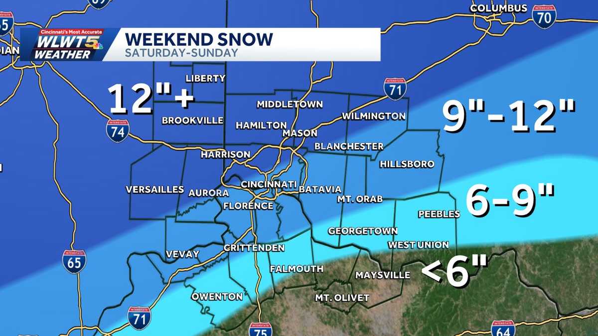
A severe winter storm has moved in, set to affect millions of Americans, including in the Greater Cincinnati region.Watch the video above for a timeline of when the winter storm could bring the heaviest snow to Cincinnati this weekend.Winter Storm WarningA Winter Storm Warning is in effect for the entire region through Monday afternoon.A Cold Weather Advisory goes into effect midnight Sunday through 6 p.m. Monday. An Extreme Cold Watch goes into effect Monday evening through Tuesday morning.LIVE RADAR // LATEST WEATHER ALERTS // TRAFFIC MAP Cold temperatures have arrived and have set the stage for this winter storm that will leave impactful snow in the Cincinnati area. Expected snowfallAt the moment, expected totals from the storm are hovering around 9-12 inches of snow, with larger amounts in the northern parts of the region.Areas northwest of the I-275 loop get around 12 or more inches. The further southeast in Kentucky along the AA Highway, totals will be closer to 6 inches or so.>>Go to the WLWT weather page | Subscribe to WLWT’s YouTube channelInitially, about 1-3 inches of snow falls Saturday night, while heavier snow arrives after midnight/predawn Sunday. Snow is heaviest on Sunday during the day. There is still the chance of sleet working in to our southernmost counties. Wintry weather continues all day Sunday before wrapping up in the night. ImpactsThis storm will have major travel impactsThis will be a heavy snowfall, so keep that in mind for clean up. Roads are likely to be most hazardous Sunday and Monday. » Follow WLWT: Facebook | Twitter | Instagram Cold Follows Dangerously cold temperatures are around through at least Tuesday. Whatever snow we do get is likely to stick around for a while. A Cold Weather Advisory goes into effect midnight Sunday through 6 p.m. Monday. An Extreme Cold Watch goes into effect Monday evening through Tuesday morning. WLWT Weather is Cincinnati’s Most Accurate Forecast, confirmed by WeatheRate, a national research company. The WLWT Weather team led by Chief Meteorologist Kevin Robinson is the only station each year to earn the Most Accurate rating.
A severe winter storm has moved in, set to affect millions of Americans, including in the Greater Cincinnati region.
Watch the video above for a timeline of when the winter storm could bring the heaviest snow to Cincinnati this weekend.
Winter Storm Warning
A Winter Storm Warning is in effect for the entire region through Monday afternoon.
A Cold Weather Advisory goes into effect midnight Sunday through 6 p.m. Monday. An Extreme Cold Watch goes into effect Monday evening through Tuesday morning.
LIVE RADAR // LATEST WEATHER ALERTS // TRAFFIC MAP
Cold temperatures have arrived and have set the stage for this winter storm that will leave impactful snow in the Cincinnati area.
Expected snowfall
At the moment, expected totals from the storm are hovering around 9-12 inches of snow, with larger amounts in the northern parts of the region.
Areas northwest of the I-275 loop get around 12 or more inches. The further southeast in Kentucky along the AA Highway, totals will be closer to 6 inches or so.
>>Go to the WLWT weather page | Subscribe to WLWT’s YouTube channel
Initially, about 1-3 inches of snow falls Saturday night, while heavier snow arrives after midnight/predawn Sunday. Snow is heaviest on Sunday during the day.
There is still the chance of sleet working in to our southernmost counties. Wintry weather continues all day Sunday before wrapping up in the night.

Impacts
- This storm will have major travel impacts
- This will be a heavy snowfall, so keep that in mind for clean up.
- Roads are likely to be most hazardous Sunday and Monday.
» Follow WLWT: Facebook | Twitter | Instagram
Cold Follows
Dangerously cold temperatures are around through at least Tuesday. Whatever snow we do get is likely to stick around for a while.
A Cold Weather Advisory goes into effect midnight Sunday through 6 p.m. Monday. An Extreme Cold Watch goes into effect Monday evening through Tuesday morning.

WLWT Weather is Cincinnati’s Most Accurate Forecast, confirmed by WeatheRate, a national research company. The WLWT Weather team led by Chief Meteorologist Kevin Robinson is the only station each year to earn the Most Accurate rating.