Severe storms bringing damaging winds, large hail, flooding and a threat for tornadoes are expected to hit southeastern Wisconsin on Friday night.The storms are forecast to impact the area from 5 to 11 p.m., with rain potentially lingering through early Saturday morning. Any sunshine breaking through the clouds will help fuel stronger thunderstorm activity later in the day. Follow live updates below.Interactive Radar7:57 p.m. A Tornado Warning has been issued for Milwaukee County until 8:45 p.m. Waukesha County has been extended until 8:45 p.m.7:47 p.m. A Tornado Warning has been extended until 8:45p.m. for Walworth, Kenosha and Racine counties until 8:45 p.m. 7:44 p.m. A Flash Flood Warning has been issued for Milwaukee, Jefferson, Racine, Walworth and Waukesha counties until 10:45 p.m. 7:35 p.m. The tornado warning for Racine and Waukesha counties has been extended until 8 p.m. 7:26 p.m. A new severe thunderstorm warning has been issued for Milwaukee, Ozaukee, Washington, Waukesha until 8:15 p.m. 7:12 p.m. Tornado warnings issued for Racine, Kenosha and Walworth counties until 8 p.m. 7:09 p.m. A Tornado Warning has been issued for Waukesha County until 7:45. WISN 12 News’ Matt Smith says the sirens are going off.7:06 p.m. A Severe Thunderstorm Warning has been issued for Milwaukee, Kenosha Racine, Walworth counties until Waukesha counties.7:03 p.m. A Flash Flood Warning has been issued for Jefferson and Dodge counties until 10:15 p.m. 6:46 p.m. A Tornado Warning has been issued for Dodge and Jefferson counties until 7:30 p.m. 6:42 p.m. A severe thunderstorm warning has extended for Fond du Lac, Sheboygan and Washington counties until 7:30 p.m. Ozaukee County is also included now.6:40 p.m. Tornado Warning extended in Walworth County until 7:15 p.m. 6:27 p.m. A new severe thunderstorm warning has been issued for Jefferson, Walworth and Waukesha counties until 7:30 p.m. 6:18 p.m. A Tornado Warning has been issued in Walworth County until 6:45 p.m. 6:05 p.m. A Tornado Warning was issued briefly for Jefferson and Waukesha counties. 5:50 p.m. A severe thunderstorm warning has now been issued for Fond du Lac, Sheboygan and Washington counties until 6:30p.m. Washington County’s was expanded until 6:45 p.m. 5:26 p.m. A severe thunderstorm warning has also been issued for Waukesha and Walworth counties until 6:30 p.m. 5:19 p.m. A new Severe Thunderstorm Warning has been issued for Jefferson and Dodge counties until 6:15 p.m. 5:15 p.m. Severe thunderstorm warning canceled for Jefferson County. 4:46 p.m. WIS 241 (27th Street) near the Root River is closed in both directions in Milwaukee County because of high water levels. 4:40 p.m. The tornado warning for Dodge County has been canceled. 4:35 p.m. A severe thunderstorm warning has been issued for Jefferson County until 5:15 p.m. 4:28 p.m. A Tornado Warning has been issued for Dodge County until 5:15 p.m. 4:12 p.m. All MPS after-school recreation, athletics and other programs and events are canceled for Friday, April 17. All after-school camps, Safe Places, and Community Learning Centers (CLC) will remain open for students, but families are strongly encouraged to pick up their students early. 3:15 p.m. Wauwatosa School District and Wauwatosa Recreation Department activities and events scheduled for after 5 p.m. Friday, April 17, are canceled. Elkhorn and Menomonee Falls school districts have also canceled Friday evening activities. 12:40 p.m. The National Weather Service issued a tornado watch until 8 p.m. for several counties, including Milwaukee, Sheboygan, Racine, Kenosha, Waukesha, Walworth, Jefferson, Fond du Lac and Kenosha counties. A tornado watch means conditions are favorable for tornadoes and severe thunderstorms in and close to the watch area. Flooding may be the top concern as the region has already received nearly seven inches of rainfall over the past seven days, nearly double the typical monthly amount of 3-4 inches. Be prepared for sudden changes and flash flooding to occur.A flood watch is in effect for the entire area, with various flood warnings issued for rivers, streams and creeks. An additional 1-3 inches of rain is expected tonight, and with the ground already saturated, water has nowhere to go.The storms are expected to move from west to east, with communities including Sheboygan, Grafton, Milwaukee, Oak Creek, Caledonia, Racine and Burlington in the path of heavy rain and strong to severe storms. The worst conditions are expected between 6-10 p.m., with the severe weather pushing out of the area around 10-11 p.m.Outdoor sirens are designed to be heard outside, not inside homes. It’s important that you have a weather alert radio or the 12 News app available indoors. Make sure your phones or mobile devices are charged up, in case power goes out.Following the storms, a strong cold front will bring cooler air over the weekend with temperatures closer to normal for mid-April. Dry conditions are expected to return next week.
Severe storms bringing damaging winds, large hail, flooding and a threat for tornadoes are expected to hit southeastern Wisconsin on Friday night.
The storms are forecast to impact the area from 5 to 11 p.m., with rain potentially lingering through early Saturday morning. Any sunshine breaking through the clouds will help fuel stronger thunderstorm activity later in the day. Follow live updates below.
7:57 p.m. A Tornado Warning has been issued for Milwaukee County until 8:45 p.m. Waukesha County has been extended until 8:45 p.m.
7:47 p.m. A Tornado Warning has been extended until 8:45p.m. for Walworth, Kenosha and Racine counties until 8:45 p.m.
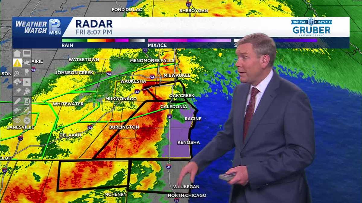
7:44 p.m. A Flash Flood Warning has been issued for Milwaukee, Jefferson, Racine, Walworth and Waukesha counties until 10:45 p.m.
7:35 p.m. The tornado warning for Racine and Waukesha counties has been extended until 8 p.m.
7:26 p.m. A new severe thunderstorm warning has been issued for Milwaukee, Ozaukee, Washington, Waukesha until 8:15 p.m.
7:12 p.m. Tornado warnings issued for Racine, Kenosha and Walworth counties until 8 p.m.
7:09 p.m. A Tornado Warning has been issued for Waukesha County until 7:45. WISN 12 News’ Matt Smith says the sirens are going off.
7:06 p.m. A Severe Thunderstorm Warning has been issued for Milwaukee, Kenosha Racine, Walworth counties until Waukesha counties.
7:03 p.m. A Flash Flood Warning has been issued for Jefferson and Dodge counties until 10:15 p.m.
6:46 p.m. A Tornado Warning has been issued for Dodge and Jefferson counties until 7:30 p.m.
6:42 p.m. A severe thunderstorm warning has extended for Fond du Lac, Sheboygan and Washington counties until 7:30 p.m. Ozaukee County is also included now.
6:40 p.m. Tornado Warning extended in Walworth County until 7:15 p.m.

6:27 p.m. A new severe thunderstorm warning has been issued for Jefferson, Walworth and Waukesha counties until 7:30 p.m.
6:18 p.m. A Tornado Warning has been issued in Walworth County until 6:45 p.m.
6:05 p.m. A Tornado Warning was issued briefly for Jefferson and Waukesha counties.
5:50 p.m. A severe thunderstorm warning has now been issued for Fond du Lac, Sheboygan and Washington counties until 6:30p.m. Washington County’s was expanded until 6:45 p.m.
5:26 p.m. A severe thunderstorm warning has also been issued for Waukesha and Walworth counties until 6:30 p.m.
5:19 p.m. A new Severe Thunderstorm Warning has been issued for Jefferson and Dodge counties until 6:15 p.m.
5:15 p.m. Severe thunderstorm warning canceled for Jefferson County.
4:46 p.m. WIS 241 (27th Street) near the Root River is closed in both directions in Milwaukee County because of high water levels.
4:40 p.m. The tornado warning for Dodge County has been canceled.
4:35 p.m. A severe thunderstorm warning has been issued for Jefferson County until 5:15 p.m.
4:28 p.m. A Tornado Warning has been issued for Dodge County until 5:15 p.m.
4:12 p.m. All MPS after-school recreation, athletics and other programs and events are canceled for Friday, April 17. All after-school camps, Safe Places, and Community Learning Centers (CLC) will remain open for students, but families are strongly encouraged to pick up their students early.
3:15 p.m. Wauwatosa School District and Wauwatosa Recreation Department activities and events scheduled for after 5 p.m. Friday, April 17, are canceled. Elkhorn and Menomonee Falls school districts have also canceled Friday evening activities.
12:40 p.m. The National Weather Service issued a tornado watch until 8 p.m. for several counties, including Milwaukee, Sheboygan, Racine, Kenosha, Waukesha, Walworth, Jefferson, Fond du Lac and Kenosha counties.
A tornado watch means conditions are favorable for tornadoes and severe thunderstorms in and close to the watch area.
Flooding may be the top concern as the region has already received nearly seven inches of rainfall over the past seven days, nearly double the typical monthly amount of 3-4 inches. Be prepared for sudden changes and flash flooding to occur.

A flood watch is in effect for the entire area, with various flood warnings issued for rivers, streams and creeks. An additional 1-3 inches of rain is expected tonight, and with the ground already saturated, water has nowhere to go.
The storms are expected to move from west to east, with communities including Sheboygan, Grafton, Milwaukee, Oak Creek, Caledonia, Racine and Burlington in the path of heavy rain and strong to severe storms.
The worst conditions are expected between 6-10 p.m., with the severe weather pushing out of the area around 10-11 p.m.

Outdoor sirens are designed to be heard outside, not inside homes. It’s important that you have a weather alert radio or the 12 News app available indoors. Make sure your phones or mobile devices are charged up, in case power goes out.
Following the storms, a strong cold front will bring cooler air over the weekend with temperatures closer to normal for mid-April. Dry conditions are expected to return next week.