The WYFF News 4 weather team continues to track the potential for a winter storm to hit the area this weekend. The following forecast is as of Wednesday night: Latest from Chief Meteorologist Chris Justus:The latest European model run is the most concerning I’ve seen so far. It now shows a significant ice storm across much of the Carolinas, with most — if not nearly all — of the precipitation falling as freezing rain, and very little sleet or snow mixed in.That is the worst-case scenario.What raises concern further is the strong surface wind field developing as the storm peaks. The European model shows wind gusts up to 45 mph on Sunday, right when icing would be at its worst. Ice + wind is a dangerous combination. The weight of ice on trees and power lines, combined with gusty winds, would likely lead to widespread power outages if this solution verifies.Why this matters now:You need to begin planning today for the possibility of losing power Saturday night into Sunday, potentially for multiple days, while temperatures turn brutally cold behind the system.Have a safe alternative heat sourceUse generators outdoors only, far from the homeBe mindful of carbon monoxide risksMake sure you have medications, batteries, food, and waterIf you don’t have a safe heat option, identify a friend, family member, or hotel nowBoth of our most reliable long-range models are signaling a major ice storm, and they have been remarkably consistent today. While the overall storm track has shifted north, it has not removed our winter weather threat. Areas south of Atlanta appear more likely to transition to rain — we do not.One more important note: hurricane hunter aircraft are sampling this system today, coast to coast. Newer models fed by that data show the ice line pushing further south to Columbia and Atlanta.But based on what we know right now, this is not a storm to wait on. I would plan for a major ice storm and prepare accordingly.I am very concerned by today’s guidance — and I promise to keep you updated as new data comes in.About the WYFF News 4 weather team:The WYFF News 4 weather team has been independently certified for having the most accurate forecast in the Greenville-Spartanburg-Asheville-Anderson market for the second year in a row.“Our goal every day, in every forecast is accuracy,” said WYFF 4 President and General Manager Blake Bridges. “Our expert weather team is dedicated to giving viewers a forecast they can trust to be right. We are also the only station in the market with our own 24/7 live radar, Live Super Doppler 4. It’s clear that WYFF News 4 is the weather leader in this market.”The certification comes from WeatheRate, an independent research firm that tracks forecasts from every station in multiple markets across the country.“Everyone knows that forecasting the weather around here is difficult with the Upstate and mountains,” said WeatheRate President Bruce Fixman. “The station that gets the forecast right more than anyone else is Chief Meteorologist Chris Justus and the WYFF News 4 weather team.”Meet the Team: Chief Meteorologist Chris Justus Meteorologist Victoria Kokinos Meteorologist Bradford Ambrose Meteorologist Grace Lowe
The WYFF News 4 weather team continues to track the potential for a winter storm to hit the area this weekend.
The following forecast is as of Wednesday night:


Latest from Chief Meteorologist Chris Justus:
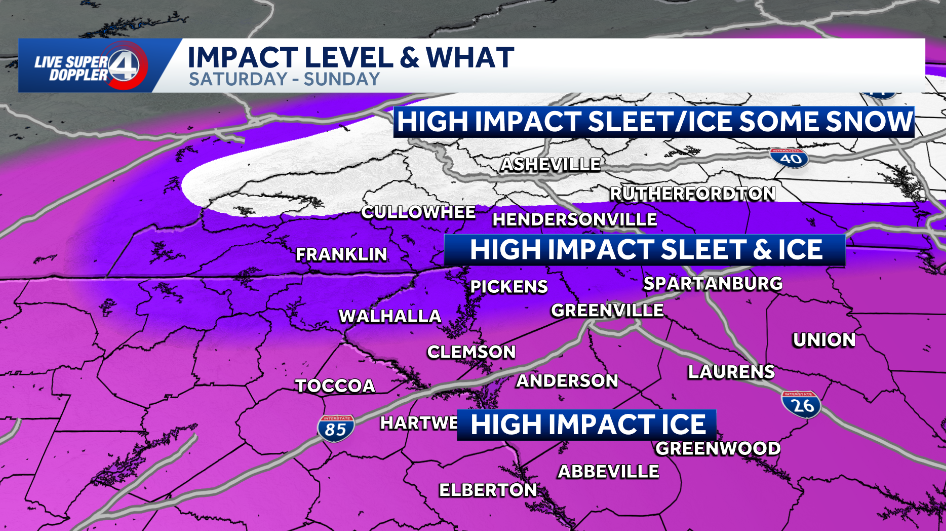
The latest European model run is the most concerning I’ve seen so far. It now shows a significant ice storm across much of the Carolinas, with most — if not nearly all — of the precipitation falling as freezing rain, and very little sleet or snow mixed in.
That is the worst-case scenario.
What raises concern further is the strong surface wind field developing as the storm peaks. The European model shows wind gusts up to 45 mph on Sunday, right when icing would be at its worst. Ice + wind is a dangerous combination. The weight of ice on trees and power lines, combined with gusty winds, would likely lead to widespread power outages if this solution verifies.
Why this matters now:
You need to begin planning today for the possibility of losing power Saturday night into Sunday, potentially for multiple days, while temperatures turn brutally cold behind the system.
- Have a safe alternative heat source
- Use generators outdoors only, far from the home
- Be mindful of carbon monoxide risks
- Make sure you have medications, batteries, food, and water
- If you don’t have a safe heat option, identify a friend, family member, or hotel now
Both of our most reliable long-range models are signaling a major ice storm, and they have been remarkably consistent today. While the overall storm track has shifted north, it has not removed our winter weather threat. Areas south of Atlanta appear more likely to transition to rain — we do not.
One more important note: hurricane hunter aircraft are sampling this system today, coast to coast. Newer models fed by that data show the ice line pushing further south to Columbia and Atlanta.
But based on what we know right now, this is not a storm to wait on. I would plan for a major ice storm and prepare accordingly.
I am very concerned by today’s guidance — and I promise to keep you updated as new data comes in.
This content is imported from Facebook.
You may be able to find the same content in another format, or you may be able to find more information, at their web site.
About the WYFF News 4 weather team:
The WYFF News 4 weather team has been independently certified for having the most accurate forecast in the Greenville-Spartanburg-Asheville-Anderson market for the second year in a row.
“Our goal every day, in every forecast is accuracy,” said WYFF 4 President and General Manager Blake Bridges. “Our expert weather team is dedicated to giving viewers a forecast they can trust to be right. We are also the only station in the market with our own 24/7 live radar, Live Super Doppler 4. It’s clear that WYFF News 4 is the weather leader in this market.”
The certification comes from WeatheRate, an independent research firm that tracks forecasts from every station in multiple markets across the country.
“Everyone knows that forecasting the weather around here is difficult with the Upstate and mountains,” said WeatheRate President Bruce Fixman. “The station that gets the forecast right more than anyone else is Chief Meteorologist Chris Justus and the WYFF News 4 weather team.”
Meet the Team:
Source link
See more https://theglobaltrack.com/