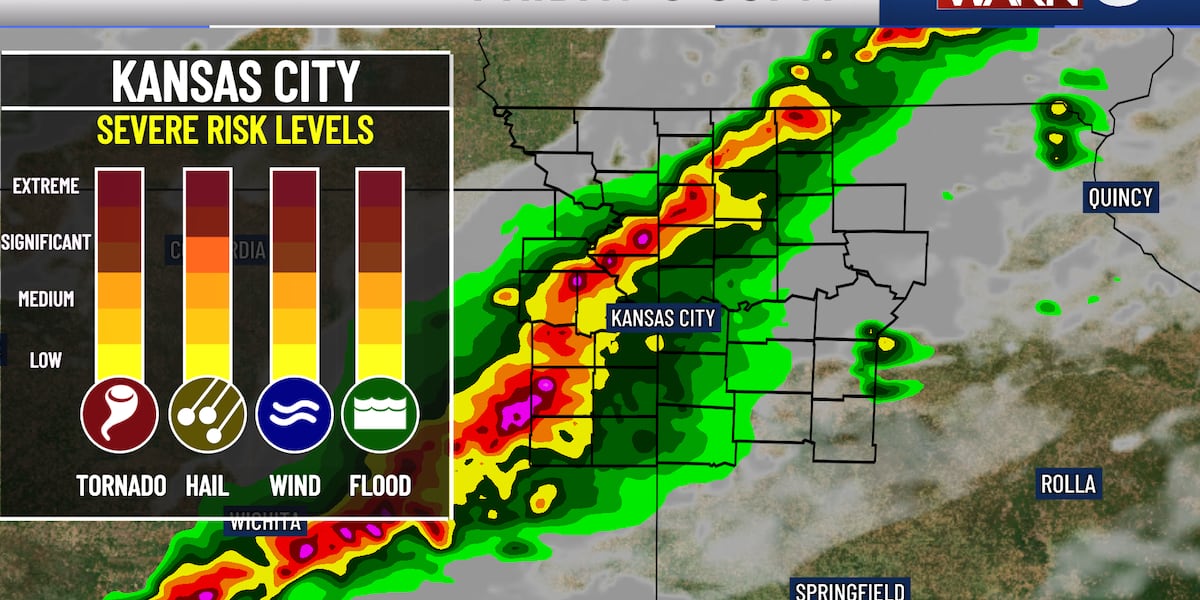
KANSAS CITY, Mo. (KCTV) – Friday brings the most significant severe weather threat of the week.
A First Warn Weather Day — our highest alert level — is in place as strong winds, large hail, tornadoes, and heavy rain are all possible.
Everyone is expected to see thunderstorms this afternoon, but not all of them will be severe. Some of us will just see regular spring storms, but we must all be prepared for warnings and dangerous weather.
WHAT TO EXPECT TODAY
Storms will likely develop this afternoon with widespread thunderstorms expected.
The main window for severe weather is between 2 and 7 p.m. for the Kansas City area, so be weather aware as schools are letting out, and for your commute home.
Have a reliable way to receive warnings. The severe threat ends for Kansas City near sunset, though rain could continue into the evening.
A line of storms will move through the region, but a few storms ahead of the line could become supercells. In those supercells, all hazards are possible — including a higher tornado threat and very large hail.
For the main line of storms, the primary threat is damaging wind, though spin-up tornadoes are possible. Extreme straight-line winds may be the biggest concern, with pockets of hurricane-force 75 mph wind gusts possible. This type of damage can be similar to tornado damage and cause significant power loss.
BEFORE THE STORMS ARRIVE
Expect partly cloudy skies this morning with temperatures near 70. High temperatures will reach the mid 80s, paired with humidity and windy conditions. Winds will be sustained between 15-20 mph, gusting up to 40 mph before storm activity arrives.
STAY PREPARED
Have a way to receive weather alerts. Download the KCTV5 Weather app to get the latest updates sent directly to your phone. Keep your phone charged and have a storm bag ready.
To get the latest weather updates sent to your phone, download the KCTV5 Weather app here.
WEEKEND OUTLOOK: CLEARING AND COOLING
The good news? Storms clear out after Friday, and dry conditions take over for the rest of the weekend and into next week.
Expect much cooler temperatures with highs in the upper 50s Saturday and 70 Sunday. Northwest winds will remain breezy. Lows will dip to the low 40s Saturday morning and the 30s Sunday morning — frost is possible Sunday morning.
Dry conditions look to continue into mid-week next week with temperatures rebounding into the 70s.
Copyright 2026 KCTV. All rights reserved.


![Iga Świątek – Mirra Andriejewa [RELACJA NA ŻYWO]. Live tenis. WTA Stuttgart](https://www.ubirataonline.com.br/wp-content/uploads/2026/04/Iga-Swiatek-Mirra-Andriejewa-RELACJA-NA-ZYWO-Live-tenis.jpeg)