Where To Watch For Tornadoes, Hail Early Week
The Storm Prediction Center has issued a 4 out of 5 risk for severe weather today, warning that “strong to intense tornadoes” are likely across portions of Missouri and Illinois.
There is a significant threat of very large tornadoes (EF3+), baseball-sized hail and damaging wind gusts.
This is all part of the dangerous severe weather outbreak that has been ongoing for several days and has already claimed two lives.
Here is our latest forecast for each day of this latest siege of severe weather.
(MORE: Severe Weather Safety Tips)
Happening Now
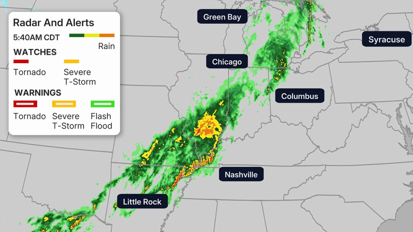
Storms producing very large hail, a few tornadoes, damaging winds and some flooding are impacting the Central Plains and the mid-Mississippi River Valley. The map below shows a radar of the current situation.
A tornado watch: valid until 9 P.M. CDT for parts of Illinois and Missouri, including St. Louis and Springfield, Missouri.
A severe thunderstorm watch: valid 4 P.M. CDT for central and southern Illinois.
A severe thunderstorm watch: valid until 6 P.M. CDT for central and western Indiana. This watch includes Indianapolis.
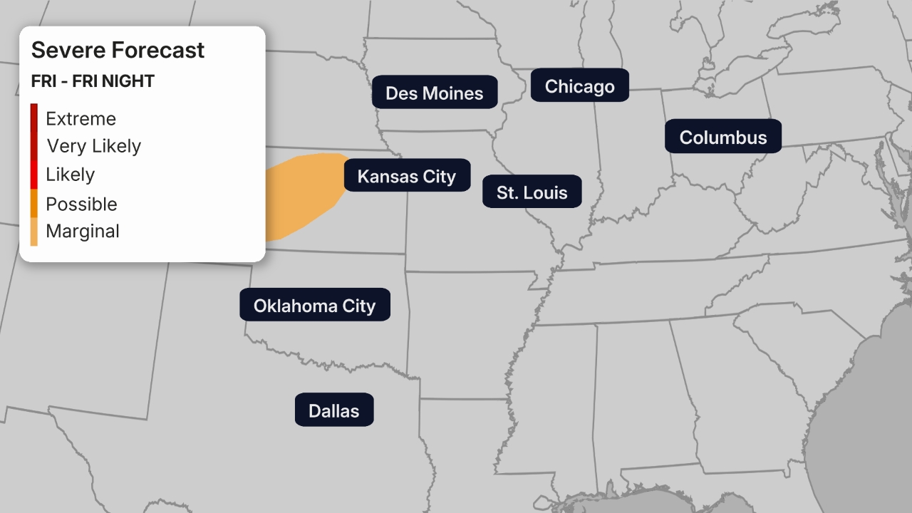
St. Louis In The Highest Threat Monday
Anyone traveling to or through St. Louis today needs to be very careful as the city is the bullseye of the great storm threat.
Later today, the higher severe threat will spread to the Mississippi Valley, lower Ohio Valley and parts of the Midwest. Today could bring even stronger and more intense tornadoes than we have seen over the last few days.
We could likely see supercells that spawn tornadoes EF3 or higher for parts of Missouri and Illinois. We will likely see very large hail as well, baseball-sized or larger, and damaging wind gusts.
These supercells are very likely to persist into the overnight hours, bringing a threat of nighttime tornadoes.
(MORE: Nighttime Tornadoes Are Especially Dangerous)
Not only St. Louis but Places like Kansas City, Little Rock, Nashville, Indianapolis, Chicago and Des Moines should all be on alert.
Tuesday: Strongest Storms From Dallas To Nashville
The lingering frontal boundary will bring some severe storms across parts of the mid-South into Tuesday. The greatest threat stretches from northeastern Texas to Kentucky.
Large to very large hail, swaths of damaging wind and a few tornadoes are possible.
Cities like Dallas, Little Rock, Shreveport, Jackson, Memphis, Nashville and Birmingham need to be watching the weather carefully.
Wednesday
The severe threat begins to wind down on Wednesday, however, there’s still a chance for storms across portions of the Deep South and mid-Atlantic.
As the front finally clears the Southeast, these storms will eventually push offshore.
This could bring some much-needed rain to parts of the Southeast that desperately needs it. However, these drough-stricken areas will also need to watch out for the possibility of flash flooding.
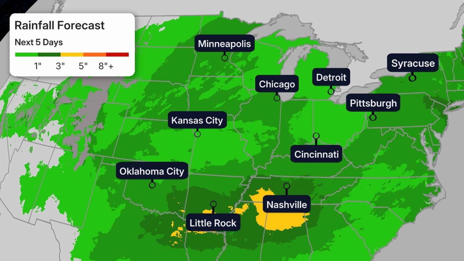
Flood Threat
This stormy pattern will bring more periods of rain to parts of the Plains and the Great Lakes. Parts of the Great Lakes still have ground saturated from the deluges both last week and earlier this spring.
For the Midwest, we don’t anticipate the magnitude of rainfall we saw last week. Over an inch of additional rain is a good bet in much of the Midwest through Monday. Even though that isn’t much, that could lead to isolated flash flooding and could slow the fall of rivers still in flood stage.
Rainfall across the Plains could be high across local areas as storms have been training over many of the same areas. These storms could cause pockets of flooding. Flood watches remain until Monday evening include the Kansas City metro.
Over the next few days, some of this rain will push into areas across the Southeast that desperately need it.
Beware of flooded roads, especially at night when you may not recognize them as fast. Never attempt to drive through a flooded road. Turn around, instead.
(MORE: Flash Flood Safety Tips)
Recap
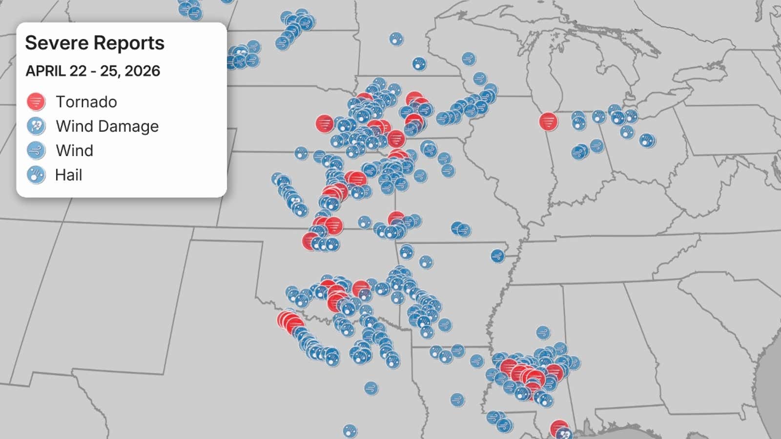
Thursday brought over 20 tornado reports from Oklahoma to Iowa, as well as over 160 damaging wind and hail reports combined.
On Thursday evening, a rare tornado emergency was issued for the storm that tore through Enid, Oklahoma and the nearby Vance Air Force Base, warning of catastrophic damage and threat to life. The resulting tornado was rated EF4 with winds of 170-175 mph. It was the first EF4 in Garfield County, Oklahoma, since April 26, 1991. There were 10 injuries from this tornado.
There were five other tornadoes reported from the National Weather Service in Norman, Oklahoma.
The NWS office in Norman noted it was only the ninth time the office has issued a tornado emergency.
(MORE: Different Types Of Tornado Warnings)
There was also a gust of 107 mph at Vance Air Force Base, Oklahoma. The most impressive hail report was a report of 4 inches in diameter, or softball-sized hail, in Marion, Kansas.
As forecasted, Friday was less impactful. There was only one tornado report in Kiowa, Oklahoma, but there were 10 tornado reports in Mississippi. There was more than 110 damaging wind and large hail reports combined.
Saturday brought more intense storms, and roughly a dozen tornado reports, mainly across Texas and Oklahoma. In Alpine, Arkansas, there was a hail stone recovered that was between 4-5 inches in diameter. Other reports of hail the size of tennis balls and hen eggs and even some reaching the size of softballs across Kansas and Texas.
As storms continued through Texas early Sunday morning, two people were killed. One person in Wise County and another person in Parker County.
On Sunday, there were over 80 hail reports, over 40 damaging wind reports and seven tornado reports across the Plains. Some tornado warnings even had Particularly Dangerous Situation tags indicating large and powerful tornadoes. Notable ones were reported in Sycamore, Kansas as well as near Joplin, Missouri. Joplin is no stranger to powerful tornadoes.
(MORE: Joplin EF5 Tornado In 2011)
There was a damage report in Edgerton, Kansas, stating that a barn has been destroyed and homes have been damaged. Numerous reports of downed trees and powerlines were reported in Missouri and Kansas.
Multiple roads were flooded in Kansas and Missouri, with numerous water rescues being reported in the Kansas City metro.
For more on the severe weather on Sunday as it unfolded, click the link below.
(MORE: Live Updates | April 26)
Make sure you have multiple ways to receive alerts, should severe weather strike in your area.
Jennifer Gray is a weather and climate writer for weather.com. She has been covering some of the world’s biggest weather and climate stories for the last two decades.